Hiking in Bulgaria
All content copyright © 2010-2024 Frank Revelo, www.frankrevelo.com, United States copyright office registration number TX-7931345
Be sure to check Hiking in Europe page for additional information and links.
Best time of year to hike is August and September for elevations above 1500m, and September and October for lower elevations. Spring and early summer are typically wet, with lots of ticks and mosquitoes at lower elevations. Mid summer can be very hot. After October, temperatures can be very cold, especially at higher elevations, with snow in winter.
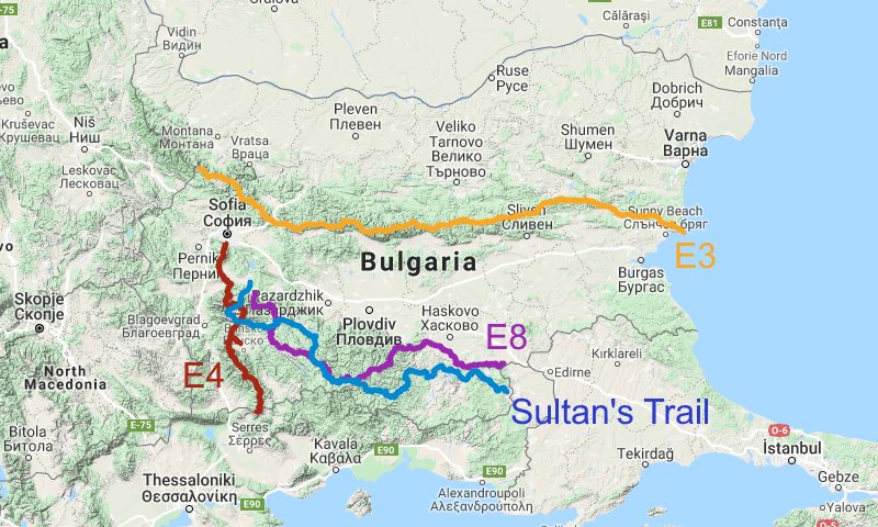
E3
GPX, Google Maps. (Possibly better GPX at WaymarkedTrails.org.) About 558km. E3 guidebook available here and also at some bookstores in Sofia.
I hiked western half of E3 (west of Dobrila hut) in 2017 (see here) and eastern half in 2018 (see here) in 27 days total, not counting rest days. GPX mostly accurate, though tends to remain on zigzagging roads rather than following more direct foot trail. Trail normally well marked, so follow waymarks in preference to GPX where they differ, especially in well-maintained central section. Bgmountains.org map shows almost completely accurate E3, while OpenAndroMaps map shows mostly accurate E3 (more about maps below).
Lift Sopot is cable chair lift connecting lower station at 590m in town of Sopot with upper station at 1390m (800m ascent/descent), just below Dobrila Hut at 1790m. Sopot has frequent bus connections to Karlovo, which has frequent connections to Plovdiv. Dobrila hut near midpoint of E3, thus good place to take rest break and resupply with trail food from grocery store.
In west and east sections of E3, mountain huts shown on maps may not be open or may have very limited food, so I recommend ability to carry 4.5L water, 3 days food, 5 days power for electronics.
E4
GPX, Google Maps. (Possibly better GPX at WaymarkedTrails.org.) About 243km.
I hiked E4 in 2017 (see here) in 16 days not counting rest days. GPX accurate other than trivial instances where it shows straight trail rather than switchbacks. Follow E4 waymarks in these cases. At south end of Rila mountains, after Mt Kapatnik, I followed first well-used dirt road I encountered to get Razlog (this detour included in GPX file above) rather than descending along E4 to highway, so I can't confirm GPX track for this section. Another hiker who did descend directly to highway reported trail there was overgrown and poorly marked, so that he ended up bushwacking his way down.
In 2022 (see here), I hiked loops combining E4 with other trails shown on GPS maps. I plan to continue hiking such loops in late August and September in the future, since such loops are more satisfying to me than strictly following E4 trail.
To get to start of E4, take Sofia metro to Vitosha station, then bus 93 to Dragalevtsi ski lift. On Saturdays, Sundays and holidays, bus 66 goes from Vitosha metro station to ski resort at top of ski lift, cutting out 1000m of ascent. Bus information current as of August 2022. To get to ski resort weekdays, without walking up, hire a taxi. Path to ski station shaded and not bad when mild temperatures in Sofia, but best avoided when very warm.
E4 has plenty of huts, so I recommend ability to carry 3L water, 2 days food, 3 days power for electronics. Even that capacity is only needed for southernmost section.
E8
GPX, Google Maps. (Possibly better GPX at WaymarkedTrails.org.) About 423 km.
I hiked most of E8 in 2019 (see here) in 23 days, not counting rest days or 2 days detouring to/from Velingrad. I hiked parts of E8 in 2022 (see here).
GPX usually accurate and/or trail usually well waymarked west of Mineralni Bani. Unmarked road walk from Mineralni Bani to Teketo. Well waymarked from Teketo to Lyaskovets, though waymarkings sometimes differ significantly from GPX and from trail shown on maps. After leaving highway 593 east of Lyaskovets, fork right twice, walk south along west side of field, look east for gap in trees where dirt road descends from field into valley bottom, ascends on other side, eventually merges with well traveled dirt road to Dolno Sadievo. Route just described from highway to Dolno Sadievo runs about 800m south of GR8 GPX, visible on Google maps, shown on bgmountains.org map, not shown on OpenAndroMaps.org map. East of Dolno Sadievo, E8 follows dirt roads along ridge.
In 2019, border control police stopped me as I approached eastern endpoint of trail (near Greek border) and made me backtrack to paved road—this may also happen to other foreign hikers.
Several sections of E8 have limited resupply. I recommend ability to carry 4.5L water, 4 days food, 5 days power for electronics.
Sultan's Trail
Digital pack, including current GPX and PDF with resupply and lodging info, can be purchased/downloaded from official trail website. Be sure to replace official GPX files in main folders with newer GPX files in "Tracks 2022 Modified" or similarly named folder. (Google Maps of older version.) About 518km for mountain route from Samokov to Greek border. (72km section between Serbian border and Sofia is lowland road walking. 71km section from Sofia to Samokov mostly coincides with E4.) Coincides with E8 in some places. (As of 2023, digital pack includes GPX for supplementary lowland route from Sofia to the Greek border, passing through Plovdiv and Haskovo. This might be perfect for hiking in November, when mountain route would be too cold.)
I hiked Sultan's Trail mountain route in 2018 (see here), in 24 days, not counting rest days, and parts of mountain route in 2022 (see here). I had some problems with pre-2023 GPX from Sultan's trail website (problems may have been fixed, notes below assume west to east direction of travel):
- About 1km past Srednogortsi, trail disappears. Descend to highway and follow that to Madan.
- After Byal Izvor, GPX follows forest road to about 800m elevation, then turns onto overgrown trail or perhaps I couldn't find trail or perhaps bushwhacking was intended, since trail not shown on bgmountains.org map. I bushwhacked to forest roads on other side of hill, but don't recommend this. Better to follow highway to Ardino.
Sultan's Trail passes frequently through towns, but water occasionally scarce. I recommend ability to carry 4.5L water, 2 days food, 5 days power for electronics.
Best of Bulgaria Loop Trail
My own trail, which I hiked in 2022 and 2023 (see here, and here) and plan to repeat in the future, with minor variations. Start in Sofia in late August/early September. Hike E4 and other trails shown on maps in Rila and Pirin mountains during September, looping back to Samokov by end of September (when temperatures start to drop and huts start to close). Starting late September/October in Samokov: E8 (or other trails shown on maps) to Yundola, mix of Sultan's Trail mountain route and E8 to Smolyan, E8 to Mineralni Bani. Thereafter, two options. Option 1 continues on E8 to road between Tankovo and Zlatoustovo, use that road to connect to Sultan's Trail mountain route, loop back to Smolyan, arriving by end of October, and finally bus from Smolyan to Sofia. Option 2 follows Sultan's Trail lowland route back towards Sofia, passing through Plovdiv, Pazardzhik and Ihtiman. Assuming leisurely hiking days and occasional rest stops in hotels, about 5 weeks in Rila/Pirin mountains and 5 weeks in Rhodopes, at best times of years for those mountains. Can easily shorten trip with fewer rest days, longer hiking days or cutting off parts of loop.
Navigation
Locus mapping GPS app for Android discussed on GPS page. As of 2023, LoMap map of Bulgaria, available in Locus map library, is high quality, as is map at FreizeitKarte-OSM.de, but map at OpenAndroMaps.org is best, in my opinion. For external maps, be sure to download both map and map theme/style. All these maps are offline, meaning downloaded to smartphone in advance and do not require internet connection for use.
OruxMaps another mapping GPS app for Android. Does not have built-in map library, but does support both OpenAndroMaps and FreizeitKarte-OSM maps and map themes/styles. Can also download unlocked Garmin IMG files (such as map at bgmountains.org) and place into OruxMaps mapfiles directory, as described in OruxMaps user's guide (available at OruxMaps website). Bgmountains.org map is most detailed and complete map of Bulgaria hiking trails, water sources, etc, though somewhat cluttered looking.
I find Locus easier to use than OruxMaps, and so mostly used Locus with OpenAndroMaps map since 2018, with occasional use of OruxMaps for access to bgmountains.org map.
GaiaGPS mapping GPS app runs on both Android and IPhone. Builtin Gaia topo map is adequate, if combined with GPX track. Can also install bgmountains.org map using one of following methods: (a) logon to GaiaGPS.com and add this URL to your list of map sources; (b) download this TileJSON file, then upload to GaiaGPS.com to create new private map source. Read help files on GaiaGPS website for how to add/create custom map sources. In either case, map source "Bulgaria Topo Map" will appear in list of map sources for GaiaGPS on your smartphone. Download map data to smartphone in advance for offline use, same as with other GaiaGPS map sources. I used GaiaGPS during my 2017 Bulgaria hiking trip, but now prefer and recommend Locus and OruxMaps apps.
All-In-One Offline Maps for Android has bgmountains.org as builtin map source. Map tiles can be downloaded to smartphone in advance for later offline use. I tested this app briefly. For my purposes, it is about equivalent to GaiaGPS.
I have heard or read good things about Viewranger, MotionX, and Backcountry Navigator smartphone apps. However, I have not used any of these apps myself, nor do I know what maps are available for these apps. Someone also recommended Soviet Military Maps app.
For all maps, whether electronic or paper, paved road information usually accurate, but forest road and path information less reliable, for usual reasons: sometimes more or less roads/paths in actuality than shown on map, roads/paths may be overgrown or abandoned or blocked by fences, roads/paths may be routed differently from what is shown on map. Even Google Earth cannot be fully trusted, since satellite photos cannot show thin barbed wire fences with "do not enter" signs blocking roads. On other side of such fences may be owners hostile to trespassers, dangerous loose bulls, packs of vicious dogs, etc.
Wildlife
Ticks in Bulgaria are known to carry and transmit pathogens which cause Crimean-Congo hemorrhagic fever, Mediterranean spotted fever, Lyme disease, tick-borne encephalitis, and other serious diseases. As of Jan 2023, I have hiked and camped about 8 months total in Bulgaria between late August and early November, and have encountered adult ticks twice, both times while camping at low elevation in brush-filled oak forests of Rhodope mountains. I have never encountered ticks between late August and early November at higher elevations of Rila and Pirin mountains. When I hiked and camped in June, at lower elevations of Balkan mountains, I encountered multiple ticks every day, and often multiple times a day (every time I sat down to rest).
Chiggers can be abundant in high grass at low elevations in late August to early November, such as along overgrown sections of E8 east of Mineralni Bani. You'll recognize them by horrible itching after walking through such grass.
Mosquitoes are only a problem at night, and no problem if shelter has netting. Tiny flies that try to get into eyes and ears are major problem in some forests in late August to early November. I strongly recommend carrying headnet for these flies. It doesn't need to be sealed at neck: just something to cover face and keep flies from flying directly into eyes, ears and mouth.
I frequently see wild boar during the day or hear them at night but they keep their distance. Bears are less common: I've heard them several times nearby at night and seen bear tracks on trails and dirt roads, but I've never seen one in daylight in Bulgaria. I also frequently hear deer and/or elk at night. Free ranging cattle and horses also sometimes visit my campsite out of curiousity at night.
Language
Based on my experiences in 2017 through 2022, English widely spoken by people under age 30, and Russian often spoken by university educated people age 50 and above. Even Bulgarians who never studied Russian can still understand it somewhat, given large number of words in common between these languages. Modified Russian more easily understood: simply substitute Bulgarian equivalents for some extremely common words which are different in the two languages. Anyone who reads Russian can parse written Bulgarian and get gist of what is being communicated.
If you don't know any Slavic language, then I recommend at least learning Cyrillic alphabet, so as to be able to correctly pronounce Bulgarian words written in Cyrillic and to use Cyrillic keyboard (either Russian or Bulgarian) on smartphone, to allow effectively using Google Translate. Be sure to download Google Translate offline file for Bulgarian, in case no internet connection available for online translation.
Complete Bulgarian courses with MP3 audio available at Yojik.eu. In my opinion, FSI course (Foreign Service Institute of USA State Department) is better than DLI course (Defense Language Institute of USA Defense Department): shorter, better organized, more legible PDF images. I worked through FSI course myself, and this improved my Bulgarian reading ability. However, I will probably continue to prefer speaking either English or modified Russian in Bulgaria. Anki deck of vocabulary from FSI Bulgarian course available here and Bulgarian-English sentence deck here
Smartphone
Bulgaria country telephone code +359.
All my phone experience is with A1 mobile (formerly Mtel), which is the oldest mobile operator in Bulgaria and which has excellent coverage in small towns and even many remote areas. Vivacom and Telenor are competitors. In 2023, at A1 store inside Mall of Sofia in central Sofia, I purchased SIM for 20 lev, which includes 20GB data and 1000 national voice minutes valid for 30 days. Card can be refilled at small shops or official A1 stores. Each refill of 15 lev adds 20GB data and 1000 minutes valid for 25 days. Press *123# then use menu (in Bulgarian language) to show balance, etc.
Hotels
Booking.com useful for finding hotels. Sometimes booking.com shows vacancy in small hotel but either hotel is closed or no vacancy: system will not process reservation in this case.
Airbnb.com another possibility for finding lodging.
Miscellaneous
Walking in Bulgaria's National Parks by Julian Perry (2014), available on Kindle. Same author wrote Mountains of Bulgaria (1995), which is out-of-print but useful, since it contains full end-to-end guides for E3 and E4 trails, whereas newer book only covers shorter hikes in national parks. Balkan Trek is guide company run by Julian Perry.
Info about Bulgarian mountains
Foods commonly available at mountain huts
бр = брой/броеве = piece/pieces
BREAKFAST (omelets often served all day)
- пържени филии 2 бр = french toast, 2 pcs
- зкауска к-т = cheese, butter, jam, sausage
- омелет 3 яйца = 3 egg omelet
- омелет с добавки = omelet with addition (cheese, etc)
- омелет със сирене = omelet with cheese
- панирано сирене = white cheese with breading
- панирано кашкавал = yellow cheese with breading
- бъркани яйца = scrambled eggs
SALADS
- салата зеле и моркови = cabbage and carrot salad
- салата зеле = cabbage salad
- салата от домати и краставици = tomato and cucumber salad
- салата от кисело зеле = sauerkraut salad
- салата от варени картофи = boiled potato salad
- руска салата = russian salad (vegetables in mayonnaise)
- шопска салата = shopska salad (tomatoes, cucumbers, onions, feta cheese, optionally peppers and/or olives)
SOUPS
- боб супа = bean soup
- леща супа = lentil soup
- зеленчукова супа = vegetable soup
- таратор супа = yogurt cold soup (yogurt, cucumber, dill, garlic)
- пилешка супа = chicken soup
- агнешка супа = lamb soup
- шкембе супа = tripe soup
- топчета супа = small meatball soup
- чорба = another name for soup
VEGETARIAN
- картофи с ориз = potatoes with rice
- ориз с гъби = rice with mushrooms
- кисело зеле с ориз = sauerkraut w/rice
- сърми 2 бр = sarmi (stuffed grape or cabbage leaves) w/rice, 2 pcs
- чушки бюрек = stuffed peppers (peppers, eggs, cheese)
- лютеница = chutney
MEAT DISHES
- наденица = sausage
- сърми с кайма 2 бр = sarmi (stuffed grape or cabbage leaves) w/minced meat, 2 pcs
- кюфте 1 бр = circle-shape grilled mince meat, 1 pc
- кебапче 2 бр = stick-shape grilled mince meat, 2 pcs
- картофи с месо = potatoes with meat
- пиле с ориз = chicken with rice
- пиле с картофи = chicken with potatoes
- печено бутче с гарнитура = roast chicken thigh/leg or breast/wing w/garnish
- мусака с кайма = moussaka with minced meat
- свинска каварма с праз = pork kavarma w/leeks
- спагети с месо = spaghetti with meat
- свинска пържола = pork steak
- пилежка пържола = chicken steak
- шишке = shishke (grilled meat pieces)
OTHER
- хляб = bread (sold per slice = филия, slices = филийки)
- цели хляб в пакета = entire bread loaf in plastic package (huts with road connection often willing to sell bread in bulk, though bread might be frozen, especially if you buy other food as well, remote huts less willing)
- шоколад = chocolate (various brands of milk chocolate bars)
- кисело мляко = plain yogurt
- бира = beer (various brands in cans)
- вино = wine (by glass or bottle)
- ракия = rakia (strong alcoholic drink)
Trail foods
Some hikers eat only in town or at mountain huts, but I usually carry some food, for snacks during rest stops and for situations where towns or huts are far apart or closed. As elsewhere in Europe, my trail foods are: bread, cheese (semi-hard at least), dry roasted peanuts, dark chocolate. In warm weather, eliminate cheese and keep chocolate buried in pack under other food/gear so it doesn't melt. Bread and cured cheese (кашкавал) almost always available in stores in small towns but quality peanuts (фъстъци, фъстък = single peanut) and dark chocolate may not be available, so buy large quantity during stops in larger towns. Huts seldom sell quality peanuts and only chocolate is typically milk chocolate. Bulgarian bread normally lacks preservatives other than salt, so best to air dry some if planning to keep sealed in plastic in backpack more than 3 days, so that it doesn't mold. Eat bread loaf end pieces last, since these crumble less readily than inner slices.
Water
All operating mountain huts have drinking water. Closed huts usually have piped spring nearby. Piped springs are common in mountains and fountains common in towns, so that I only rarely have needed to take water from streams. Springs/fountains are shown on both Locus and bgmountains.org maps, but neither map is perfectly accurate. In particular, springs/fountains shown on maps in southeastern Bulgaria are often dry. I always hike with at least 4.5L water carrying capacity, and carefully plan water resupply strategy.