Hiking in Spain
All content (other than maps) copyright © 2010-2024 Frank Revelo, www.frankrevelo.com, United States copyright office registration number TX-7931345, maps copyright © OpenStreetMap and Frank Revelo
Be sure the check the main Hiking in Europe page for additional information and links.
Of the countries in Europe where I have hiked significantly (Britain, France, Greece, Bulgaria and Spain), Spain is my favorite for hiking in spring. Climate is normally drier and warmer than in northern Europe, there is good system of trails, costs are low. For hiking in early autumn (September-October), central France or Bulgaria are preferable, since Spain can be very hot then. Summer (July-August) is a disaster almost everywhere in Europe due to heat and crowding, though that is best time for visiting high mountains. If you really want to visit high mountains, note that Pyrenees (and especially Spanish Pyrenees) are much less visited than the Alps. And even less visited in July/August would be mountains of eastern Europe or Turkey.
As elsewhere in Europe, there are two separate systems of trails in Spain: (a) Camino de Santiago pilgrim's trails; (b) GR/PR hiking trails.
Caminos de Santiago
These trails can start anywhere in Europe, but always terminate in Santiago de Compostela in the northwest corner of Spain. The singular form "Camino de Santiago" typically refers to the most popular of these Caminos, also known as the Camino Francés, which starts at the French/Spanish border between St Jean Pied de Port in France and Roncesvalles in Spain, then runs west across the north of Spain.
Pilgrim's trails are less about getting closer to nature (though there is plenty of nature on most of these trails) than about escaping the routines of civilization and experiencing the comraderie of other pilgrims. A pilgrimage that only lasts a few days somewhat misses the point, since the it normally takes at least a week to feel fully free of old routines and get into the swing of trail life.
Camino de Santiago is the only trail system which most people in Spain know anything about. Anyone hiking in Spain with a backpack will be assumed by most Spaniards, including the police, to be a pilgrim walking one of the Caminos de Santiago. (Unless they look like a homeless person, which is the case with me, because I'm a solitary and wild-looking middle-aged male. Assuming I'm actually hiking the Camino de Santiago, saying so is a magical phrase for being left alone by the police.)
At least on the Camino Francés between April and October, it is fairly easy to get by without speaking a word of Spanish, since the locals are familiar with tourists who don't speak Spanish and there will typically be plenty of other pilgirms who can translate for you.
More popular Caminos de Santiago are physically undemanding, with no steep ascents, well-groomed walking surfaces (a mix of paved roads, dirt roads and well-maintained trails), and don't venture far from civilization, so there is never a need to carry large amounts of food nor to wild camp. On the other hand, these trails are not trivially easy either. Blisters can turn even a short walk on a flat surface with a minimal pack into an excruciating ordeal. Also, the combination of cold rain and wind, which can occur as late as June in northern Spain and will almost certainly occur at least once during a hike in April or May, can exhaust even strong hikers. What is well-groomed trail when dry can turn into a slippery bog in the rain. Finally, any hiking trail can be challenging for those with serious medical conditions, especially foot or knee problems.
Copious waymarking with yellow spray-painted arrows means most of the Caminos de Santiago are easy-to-follow, with no need for map and compass or GPS and no possibility of getting lost. (Note I wrote "copious waymarking" rather than "excellent waymarking", because I think these spray-painted arrows are a form of visual pollution and I much prefer the less conspicuous waymarkings of the GR/PR trail system.)
Guidebooks, including some in English, make it easy to find lodging and other services. And lodging options are typically plentiful. In particular, the Camino Francés has a dense system of low-cost refugios, or dormitory accommodation. (I'm no fan of dormitories, and so seek out budget hotels where available, and I suggest anyone reading this plan to do the same, unless they are truly money-constrained. It would be a shame to ruin an otherwise wonderful trip with bad memories of being kept awake many nights in succession by loud snoring from other pilgrims.)
Though wild camping is never required on the more popular Caminos de Santiago, you should still carry both a lightweight sleeping bag and ground pad so you can sleep in refugios, even if you plan to sleep mostly in hotels. This is because hotels might be full, or closed, or there simply might not be any hotel available, so that you are forced to use the refugios. The sleeping bag is needed because the refugios typically only supply mattresses, and not sheets or blanket. Synthetic-filled bags rated for 10°C (50°F) and weighing about 500 grams can be bought cheaply at most outdoors shops in Spain. This is plenty adequate for the conditions inside a refugio other than in winter. The ground pad is only needed if all the refugio beds are occupied and you have to sleep on the floor. If you've forgotten what sleeping on a cold concrete floor is like, be sure to test your ground pad in advance.
English language guides to the more popular trails can be ordered from Confraternity of Saint James. There are also FAQs and active forums at that site to answer any questions you might have. Pilgrim's credential, required to stay in some of the refugios, can be obtained at American Pilgrims. An overview map of the entire network of Spanish pilgrimage trails is available at Mundicamino, along with Spanish-language guides to these trails.
Comments about various Caminos de Santiago in Spain
Camino Francés, as noted, runs across the northern part of the country, starting near the Pyrenees. This is the most popular of the Caminos, by far. It is thus the best for beginning hikers, those who don't speak any Spanish, and those who want companionship from other pilgrims. Bitterly cold in winter. Very crowded in July and August. Weather mostly mild in April and May, with not too much crowding and longer days, so this is probably the best time for most people. Takes about 4 weeks for most people, to get from Roncevalles to Santiago de Compostela.
Vía de la Plata runs from Seville (or Cádiz) north to Zamora. One variant then runs diagonally northwest through Ourense, while another continues north and merges with the Camino Francés. The second most popular Camino de Santiago in Spain. A good choice for starting in early March, since weather is milder in southern Spain. Takes about 6 weeks for most people, for either variant, to get from Seville to Santiago de Compostela.
Camino de Levante starts in Valencia, then runs through Albacete, Toledo, Ávila and finally merges with the Vía de la Plata in Zamora. Very few pilgrims other than in July and August. A good choice for those who have done the other Caminos and want to try something different. Takes about 6 weeks for most people to get from Valencia to Santiago de Compostela.
Camino de Madrid starts in Madrid, then runs north until it merges with the Camino Francés. Convenient for those who want to start immediately from Madrid, rather than taking the bus/train from Madrid to Roncevalles. Takes about 2 weeks for most people to get from Madrid to the merger with the Camino Francés, and then another 2 weeks to get to Santiago de Compostela.
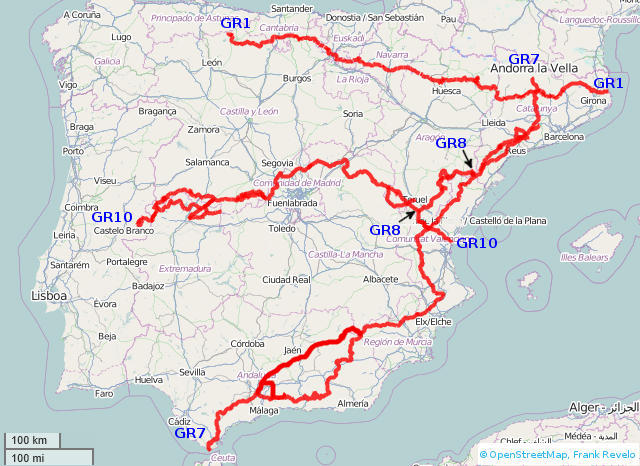
GR/PR trails
The GR (Gran Recorrido) trail system is waymarked with parallel red and white stripes, with each stripe about 5cm (2") high by about 15cm (6") wide, in accordance with the standards of the European Ramblers Association. Very few non-Spaniards can be found on these trails, other than the GR11 (a traverse of the Pyrenees from Atlantic to Mediterranean or vice-versa, 6 weeks for average hikers). And other than during July and Augusts and occasionally holiday weekends, these trails are mostly unused even by Spaniards. Typically, if I spend 3 months hiking GR trails in Spain in the spring, I will see no other long-distance hikers, and only occasionally day-hikers. So if you like solitude and you are open to more strenuous hiking (steep ascents, occasional need to use hands to climb or descend steep rock walls, etc) than is typical of the Caminos de Santiago, these are the best trails in Spain.
Historically, the main problem with the Spanish GR trail system has been finding information. For a few trails, there are guidebook/map combinations published by Prames. Assuming waymarks are not obliterated and trail is neither overgrown with thorns and other vegetation nor rerouted due to logging or construction of new highways, then the combination of guidebook plus map (1:40,000 scale, typically) is adequate. Unfortunately, the preceding assumptions are often violated in Spain. Furthermore, most trails lack guidebook/map combinations. Fortunately, as of 2013, things are rapidly changing for the better. Handheld GPS receivers have seen significant improvements in quality combined with drops in price in recent years (driven by competition from smartphones), there are now high-quality GPS topo maps available for Spain, and GPX tracks are rapidly becoming available for all the GR trails in Spain, so the problem of finding and following the trails themselves is mostly on the way to being solved. (Keeping the trails cleared of thorns and other vegetation is another story.)
Because the GR trails tend to run through remote parts of Spain only lightly visited by non-Spaniards, it is highly advisable to have basic competency at speaking, understanding and reading Spanish. Some of the more remote trails will also require carrying camping gear, since hotels may not be available. (Even if hotels are available, they might be full or closed for the season, so carrying a lightweight sleeping bag and ground pad is still advisable, as with the Caminos de Santiago. With a lightweight sleeping bag and ground pad, you can sleep on the floor somewhere, or under the stars in mild weather.)
The PR (Pequeño Recorrido) trail system is waymarked with parallel yellow and white stripes. This trail system is administered locally and consists of short trails suitable for day-hiking, branches off of a GR leading to points of interest, connectors between GR trails, etc. Book/map combinations for the GR trails sometimes also document PR trails which link to the GR in question. Similarly, GPX files for GR trails sometimes also include linking PR trails. PR trails are sometimes documented nowhere else than by physical signs at the trailhead.
An overview map of the Spanish GR trail system (as of 2009) in PDF format can be found here here (www.fedme.es, Documentación, Senderismo, "Conoce España y Portugal Caminando") or here. The map only shows part of the entire trail system, for whatever reason. For example, the map suggests the GR10 has not been completed in Guadalajara or Madrid provinces. Yet I walked this trail in these provinces in 2013 and the trail both exists and is waymarked and there are GPX tracks available at various locations on the internet. And so on.
Other trail systems
Estels del Sud, or the Southern Stars route, travels between Beceite-Arnes-Paüls-Caro-Font Ferrera in the mountains of southern Catalonia. About 20km and 800m ascent per stage.
Sometimes around 2002, I spent several months hiking in the mountains of Sierra de Courel and Sierra de Ancares in the province of Lugo in northwest Spain. The guide I used was written in Gallego (easy to understand for someone who reads Spanish fluently and reads Portuguese so-so) and included 1:50K maps. The maps had many errors, but were adequate. Probably these guidebooks are out-of-print and have been replaced by newer guidebooks. There was no waymarking of the trails and they were not part of the GR/PR system at the time. The area is very pretty, both the natural landscape and the picturesque and now mostly deserted villages, and also uncrowded.
Guidebooks/maps
In the past, following GR/PR trails required a combination of large-scale (1:50K or better) paper topo maps plus paper trail guide. The modern approach is GPS-enabled Smartphone (or standalone GPS receiver), loaded with topo maps and GPX track, plus ebook trail guides. For a small number of trails in Spain, I have created my own electronic trail guides, with GPX tracks, overview maps, accomodation information, and links to trip reports:
Visit GPS page for information about GPS receivers and GPS apps on smartphones. If using smartphone, both Locus (available on Android only) and GaiaGPS (available on both Android and IPhone) apps support free IGN maps for Spain. These are excellent electronic maps and what I would recommend using. Locus allows downloading IGN maps at all zoom levels by province, which I found simpler than GaiaGPS method of drawing rectangle around area and specifying max zoom level of map tiles to download for offline use. For this and other reasons, I would recommend Locus over GaiaGPS for Android users.
SenderosGR España has GPX tracks for most GR tracks in Spain. Other sources: WikiLoc, GPSies, Waymarked Trails, WanderMap, Euro-Senders.
Another hiker recommended Topo Pirineos as best map for GR11 traverse of Pyrenees, and Topohispania DEM 2.04 as best maps for all of Spain.
No need for topo maps or detailed trail guides for more popular Caminos de Santiago, due to copious waymarking. For less popular Camino de Santiagos, use trail guide to get past tricky spots where waymarking is inadequate, or use GPS receiver loaded with GPX track.
Bookstores, for those who prefer paper maps/guidebooks
Madrid: Instituto Geográphica Nacional de España or IGN. Calle General Ibáñez de Ibero, 3 (metro Guzmán el Bueno). Map store open weekday mornings (10:00-14:00) as of 2013. Source of paper 1:200K topo maps (one map per Spanish province), as well as other format paper maps. My last visit was 2013.
Madrid: La Tienda Verde, Calle Maudes, 23/38 (metro Cuatro Caminos). Tel: 915 353 810. Best bookstore in Spain for hiking books and maps. My last visit was 2013.
Barcelona: Libreria Quera, Calle Petritxol, 2 (metro Catalunya). Tel: 933 180 743. Second best bookstore in Spain for hiking books and maps. My last visit was 2013.
Barcelona: Libreria Altaïr, Gran Via, 616. Tel: 933 427 171. Third best bookstore in Spain for hiking books and maps, and the best for non-hiking travel books. My last visit was 2013.
Madrid: Libreria Altaïr, Gaztambide, 31. Tel: 915 435 300. Never been here, but I assume it is similar to the Barcelona store of the same name.
Teruel: Libreria Perruca, Calle Nueva, 24. Tel: 978 601 211. Has a good assortment of hiking books for Teruel province only. My last visit was 2010.
Caminos de Santiago section above has additional guidebook sources for those paths.
Voice/Internet Connectivity
For my initial hiking trips to Spain, I relied on public phones and prepaid calling cards for voice communications, and internet cafes with rental computers for internet access, but this system is obsolete. Anyone who can afford to go hiking Spain as of 2024 can afford a smartphone and mobile voice/data service. Smartphone must be both unlocked.
In 2019, I used Movistar prepaid: €15/month (I forget how month was defined), 2GB data, €0.30 per call for voice calls within Spain. In 2020, I used Lycamobile prepaid: €15/30 days, 12 GB data, including 6GB roaming, 150 minutes calling. In 2022, I used Llamaya prepaid: €10/28 days, 20GB data, unlimited calls inside Spain. In 2023, I used Yoigo prepaid: €15/month (renews same day of month, regardless of previous month length), 20GB data, unlimited calls inside Spain. In 2024, I used Másmóvil, which is affiliated with Yoigo: €10/30 days, 40GB data, unlimited calls inside Spain. O2 might be best service for hikers, because it uses Movistar network, which has best coverage in Spain. O2 SIM cards can supposedly be bought in Movistar stores, and card remains active for one year after last recharge, thus perfect for hikers like me who visit Spain every year. Just retain card between visits and reload balance upon arrival in Spain.
As of March 2024, there is store in Madrid airport which sells expensive versions of prepaid SIM cards for various mobile services (2-3 times prices listed above) and kiosk in Estación Sur de Autobuses in Madrid which sells normal priced prepaid SIM cards. Store and kiosk are not open late in the evening, so if planning late arrival, then before traveling to Spain, mark Movistar and Yoigo store locations on offline Google map, so as to get phone service working as soon as possible. In 2022, I visited 4 Movistar stores in Granada and none had prepaid SIM cards in stock. Eventually, I found repair shop with prepaid Llamaya SIM cards in stock. In 2023, Yoigo store in Granada had prepaid SIM cards in stock. In 2024, SIM card kiosk in Estación Sur de Autobuses in Madrid was still open at 21:30.
Phone account balance can be filled at various stores and kiosks within stores. Specify phone number and how many euros of service you want to buy. After paying, you get an SMS message on your phone indicating new balance.
Remember to bring or buy an adaptor for European wall outlets (all modern electronics chargers should handle either US or European voltages, though you should verify this yourself).
International telephone code for Spain is +34.
Other
(This page is about hiking in Spain and I don't currently plan to bicycle tour there. However, a reader provided the following information and I don't want to lose it, so here it is.)
Ruta TransAndalus is 2000km mountain biking route through the mountains of all eight provinces of Andalusia. Complete information here.