Hiking in Spain - GR8 Trail Guide
All content (other than maps) copyright © 2010-2024 Frank Revelo, www.frankrevelo.com, United States copyright office registration number TX-7931345, maps copyright © OpenStreetMap and Frank Revelo
Be sure the check the main Hiking in Spain and Hiking in Europe pages for additional information and links.
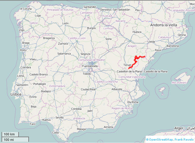
GPX track here (GR8, PR-TE1 through PR-TE8, Estels del Sud, plus waypoints showing locations of hotels/stores/fuentes). View in Google Maps here.
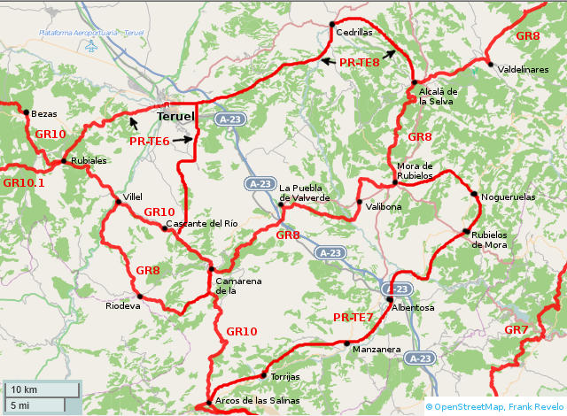
GPX file for GR8 actually contains 3 tracks: (a) main track, from Font Ferrera to Villel; (b) GR8.1 alternative which passes through Ejulve, etc; (c) loop to visit Cantavieja and La Iglesuela del Cid (plus PR-CV1 extension from La Iglesuela del Cid to Culla, intersecting with GR7).
Here is my trip report for 2013 for most of the GR8.
Here is my trip report for 2014 for a small piece of the GR8.
Official hiking organizations:
Prices below assume low season (everything except Christmas, New Year, Semana Santa, holidays, July, August). Sometimes late June, early September and weekends during spring and fall are also considered high season. Pricing information from hotelsearch.com, toprural.com, and ecoturismorural very unreliable.
Whether or not Saturday is considered high season for pricing, that day is usually the busiest at most hotels. Be prepared to camp then if you don't have a reservation.
Most towns have a water fountain. Stores in small towns face severe competition from a combination of daily fruit/bread trucks and delivery by hypermarts (ordering by internet) and many can be expected to shut down in the future. Bakeries (horno or panadería) sometimes also sell non-perishable food (canned goods, chocolate, etc). Stores and bakeries may have limited hours. It is best to always carry some extra trail food (biscuits, pan de molde, etc).
As of 2016, quantity of Airbnb.com listings is rapidly increasing for rural areas of Spain, so be sure to check that site. Booking.com is also increasingly being used by smaller hotels. But I would avoid using booking.com to make reservations and especially to pay with smaller hotels, since they often have internet problems. Sometimes booking.com shows vacancy in small hotel but either hotel is closed or no vacancy. So just use it to get availability and price range of rooms.
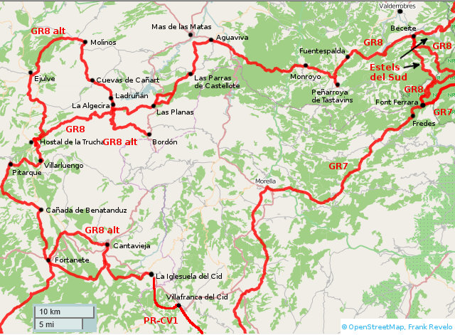
Official GR8 between Beceite and Font Ferrera is a footpath, which may be overgrown or blocked by blowdowns in early spring. Two alternatives: (a) easy forest road route to the west of the Río Maranyana; (b) Estels del Sud trail up the Río Maranyana canyon, which has a few technical spots (iron ladders bolted into the rock) and normally requires getting the feet wet, and so is for warm weather only.
Aguaviva
- Store.
- Hotel* Altabella, 978 848 238. Paid 25€ in May 2019 for single occupancy of double room with bath.
Beceite
- Bakery/stores.
- Oficina de turismo, 978 890 468.
- Albergue Casa de l'Aigua. Paid 22€ in May 2019 for bunk bed in 6 bed dorm. Double rooms 46€ according to booking.com in May 2019.
- Antigua Posada Roda. Paid 20€ in March 2013 for single occupancy of double room.
- Fond Urquizu, 978 850 233, 680 669 229.
- Hostal Racó del Toscá, 978 890 855, 606 429 854. Quote me 50€ in March 2013 for single occupancy.
- Hotel** Font del Pas, 978 890 443, 629 088 932. Website in March 2013 indicates 55€ single occupancy.
- Hotel** Fábrica de Solfa, 978 850 756, 620 217 120.
Cañada de Benatanduz
- Bar/restaurant.
- Casa Jarque (básica), 978 773 053, 696 824 376.
- Casa la Vega (básica), 978 773 079.
Cantavieja
- Store.
- Oficinia de turismo, 964 185 414.
- Hotel Balfagón, 964 185 076. 49€ single occupancy weekdays, according to website June 2013.
- Pensión La Posada, 964 185 005. Paid €30 single occupancy of double room with shared bath in May 2023.
- Casa Sara, 600 375 486. €40 for single occupancy, according to booking.com in May 2023.
Cuevas de Cañart
- Store.
- Pensión Cuevas de Cañart, 978 887 534, 686 891 836.
- Hotel** Don Íñigo de Aragón, 978 887 486. 103€ double occupancy, according to website June 2013.
- Casa
Ejulve
- Store.
- Fonda El Portal, 978 752 606.
- Hotel*** Masía Los Barrancos, 978 084 098, 630 854 844. 45€ single occupancy (lower in off-season), according to website June 2013.
- Casa Mirador del Maestrazgo, 978 752 808, 605 048 113, 45€ single occupancy, 70€ double occupancy, according to website June 2013.
- Casa María Teresa, 978 752 658.
Font Ferrera, Refugi (intersection with GR7)
Fortanete
- Bakery/store.
- Oficina de turismo, 978 778 101.
- Hostal La Muralla, 978 778 297, 638 530 716, 636 801 777. Number invalid when I called in May 2016.
- Hotel Mercadales, 978 778 125. Paid 35€ single occupancy of double room with bath in May 2016.
- Albergue La Tiñada, 978 778 144, 617 234 287. 12€/person in dormitory including sheet rental, according to website June 2013.
Fredes (see GR7 trail guide)
Fuentespalda
- Bakery/stores.
- Fonda Aparicio, 978 856 820, 978 856 182.
- Hotel La Torre Del Visco, 978 769 015. 175€ double occupancy, according to website June 2013.
- Hotel*** Mas de la Serra, 978 369 098, 676 262 272. 165€ double occupancy, according to website June 2013.
- Albergue Barranc de la Sierra, 978 856 217, 686 641 920. 30€ for double occupancy of entire room, according to website June 2013.
- Camping La Font, 978 856 506, 978 856 750, 616 374 479, 648 816 675. 18€ 1 person with tent.
Iglesuela del Cid, La
- Bakery/store.
- Oficina de turismo, 964 443 325.
- Hospedería**** de la Iglesuela del Cid, 964 443 476.
- Hostal Casa Amada, 964 443 373.
- Hotel rural El Convento, 605 396132 - 605 902 673, 40€ for double occupancy, according to toprural.com June 2013.
Ladruñán
- Albergue Crespol, 620 970 109
Mas de las Matas
- Oficina de turismo, 978 848 807.
- Casa Aznar, 677 362 359. C/La Oliva,32.
- Casa Monserrat, 978 848 966. C/Goya,8.
- Casa Rosa Mary, 978 848 831. C/Arrabal.
- Casa Soro, 686 110 069 – 978 849 970. C/Santa Lucía,53. 36€ for double occupancy, according to website May 2016.
- Camping La Palanca, 978 848 971. C/Coronilla.
Molinos
- Store.
- Oficina de turismo, 978 849 085.
- Hostal de la Villa, 978 849 234, 629 656 846. 30€ single occupancy, 45€ double occupancy, according to website June 2013.
- Albergue Santos Villacián, 978 849 400.
Monroyo
- Store.
- Oficina de turismo, 978 856 001.
- Posada* Guadalupe, 978 856 005. 44€ single occupancy, according to website June 2013.
- Hotel*** Consolación, 978 856 755, 689 020 943. 145€ single occupancy, according to website June 2013.
Parras de Castellote, Las
- Multiservicio rural serves food and has albergue, 609 961 384.
Peñaroya de Tastavins
- Bakery/store.
- Oficina de turismo, 978 899 667.
- Hotel** Tastavins, 978 896 642. 70€ single occupancy, according to website June 2013.
- Santuario Virgin de la Fuente, 978 896 802, 978 896 789, 656 236 591.
- Casa Capitana, 978 896 702, 664 643 112.
- Casa Carranclanc, 978 896 680.
- Cas Mas de L'Aragonés, 978 769 048, 978 896 786, 637 115 814. 50€ double occupancy, according to website June 2013.
- Casa Masía de la Serra de la Cogulla, 978 896 634, 686 761 817. 40€ double occupancy, according to toprural.com June 2013.
- Casa Mas de Nofre, 978 896 775, 694 910 641. 110€/night for 2 room apartment, according to website June 2013.
- Casa Pallissa, 978 896 631, 626 742 843.
Pitarque
- Oficina de turismo, 978 773 007.
- Fonda Pitarque, 978 773 236, 670 662 034. 35€ single occupancy, 50€ double occupancy, according to website June 2013.
- Casa Molina, 978 773 124, 659 774 723.
- Casa Pakita II, 978 773 051, 609 553 735. 36€ 2 persons, according to ecoturismorural.com June 2013.
Portell de Morella (about 15km from Villafranca del Cid along beautiful, unobstructed and well waymarked GR331 trail, with easy camping on route, but no fuentes)
- Hostal De Portell, 673 129 861. Paid €40 in May 2023. Would be cheaper if booked through booking.com.
Valderobres
- Hostal*** Querol, 978 850 192
- Fonda** Albesa, 978 850 063
- Fonda** La Plaza, 978 850 106
Villafranca del Cid (PR-CV1)
- Hotel Los Arcos, 964 441 442. Paid €38 single occupancy in May 2022. Closed when I stopped by in May 2023.
- Camping El Llosar, 964 913 325. 2km from town center on CV-15 (road to La Iglesuela del Cid).
Villarluengo
- Bakery/store.
- Oficina de turismo, 978 773 014.
- Pension Fonda Josefina, 978 773 151.
- Pensión Fonda Villarluengo, 978 773 014. 6 rooms with bath, 2 without. Paid 20€ single occupancy double room with bath in May 2019.
- Hostal Torre Monte Santo, 978 773 000. A km or so south of Villarluengo, on the GR8. 80€ double occupancy, according to website June 2013.
- Hostal*** de la Trucha or here, 978 773 008. A few km north of Villarluengo, on the highway and not far from the GR8. Specializes in trout fishing in the nearby river, with the hotel restaurant later cooking the fish. 50€ per room (single or double occupancy), according to website June 2013.
Albentosa
- Bakery/store.
- Hostal Los Maños or here, 978 785 863. 45€ double occupancy, according to website June 2013.
- Hostal Peiró (Casa Amparin) or here, 978 780 222. 48€ double occupancy, according to website June 2013.
Alcalá de la Selva
- Bakery/store.
- Oficina de turismo, 978 801 226.
- Hotel La Vega, booking.com advertised 65€ single occupancy in May 2016 on a Sunday.
- Casa Isabel (Superior), 978 801 184.
- Casa Julia (Básica), 978 808 099, 649 792 174.
- Casa El Molino del Conde (Superior), 978 728 071 / 645 093 394.
- Casa Vega (Básica), 978 801 212.
- Camping** Los Alamos, 978 801 167, 618 293 292. Located several km from town. 10€ 1 person with tent, according to website June 2013.
Virgen de la Vega (near Alcalá de la Selva)
- Hotel Esther, booking.com advertised 37€ single occupancy in May 2016 on a Sunday.
- Villa Maria, booking.com advertised 28€ single occupancy in May 2016 on a Sunday.
Camarena de la Sierra (see GR10 guide for accomodation info)
Cedrillas
- Bakery/store.
- Hostal Ramiro, 978 774 040, 660 813 863, 686 785 392. c/Brasiliso Muñoz, 40 (main highway). 30€ single occupancy, 50€ double occupancy of room, 60€ double occupancy of apartment, according to website May 2023. Paid 30€ for single occupancy in May 2023.
- Hostal Cedrún, 978 774 214, 978 774 296. c/Juan Carlos I, 7.
- Casa Rural Jarque, 978 774 234, 689 278 290. c/El Arrabal, 8.
- Casa Carmen, 978 774 011, 978 774 303.
- Casa Mario, 978 774 252.
- Hotel Juan Tarín, 978 774 466, 699 344 873. 40-55€ single occupancy, 50-70€ double occupancy, according to website April 2017. Located in Monteagudo del Castillo, which is a few km from Cedrillas and easily reached from PR-TE8 via dirt roads.
Manzanera
- Stores.
- Oficina de turismo, 978 781 752.
- Hostal Manzanera, 978 781 808, 676742804. On main street. 46€ double occupancy shared bath, according to website June 2013. Paid 20€ for single occupancy of room with shared bath in April 2014.
- Hotel* Duque de Calabria, 978 781 821. On main street, near end of town. 66€ double occupancy, according to website June 2013.
- Hotel* Los Cerezos, 978 781 964. A few miles south of Manzanera, and not on GR7, so inconvenient location. 80€ double occupancy half-pension, according to website June 2013.
- Albergue y Camping Villa de Manzanera, 978 781 748.
Mora de Rubielos
- All services.
- Office of tourism, 978 806 132.
- Hotel*** Mora, 978 800 177, 902 222 270. Paid €50 single occupancy in May 2023, through booking.com.
- Hotel*** Jaime 1 or here, 978 800 184 / 978 800 092. 40€ single occupancy on weekday in May 2022.
- Hotel*** la Rueda II or here, 978 800 350, 978 800 225, 687 969 202, 978 800 029. 44€ single occupancy during off-season, according to website June 2013.
- Hotel**** La Trufa Negra or here, 902 105 503 / 629 064 661. 74€ single occupancy of double room including breakfast on weekdays, 107€ weekends, according to website June 2013.
- Albergue Municipal, 978 800 311.
- Camping Público de Turismo, 670 343 185.
Nogueruelas
- Store.
- Hostal Casa Grande or here, 978 804 109.
- Hostal Crucica or here, 978 804 139, 649 450 270. 60€ double occupancy, according to website June 2013. Paid 25€ single occupancy in April 2014.
- Casa Peña Abantos, 978 728 190, 615 894 842. 100€ for double occupancy, according to toprural.com June 2013.
Puebla de Valverde, La
- Store.
- Oficina de turismo, 978 670 001.
- Hotel* El Horno or here, 978 670 406, 627 947 995. 50€ double, 35€ single occupancy, according to website May 2018. Paid 35€ single occupancy May 2018.
- Hostal Masía Pelarda or here, 978 107 901, 610 438 874. Several KM from town. 53€ double occupancy, according to website June 2013.
- Hotel*** Euroruta, 978 670 136.
- La Fonda de la Estación*** or here, 978 670 467. 72€ double occupancy, according to website June 2013.
- Habitaciones El Ventorrillo, 608 439 494, 978 670 032. A few km south of town, on the GR8. Paid €20 for single occupancy in May 2017.
- Casa El Parral, 687 711 780. 28€ 1 persons, according to ecoturismorural.com June 2013.
- Casa Tonico, 978 610 610, 679 384 509. 120€ 6 persons, according to ecoturismorural.com June 2013.
- Casa Masía Casablanca, 978 670 035 / 606 424 555. 400€ 12 persons, according to ecoturismorural.com June 2013.
Riodeva
- Bar with food.
- Albergue Mundo Perdido, 978 784 101.
Rubielos de Mora
- Bakeries/stores.
- Oficina de turismo, 978 804 001.
- Hostal Masía del Cura, 978 804 619 or 687 700 242. Carretera de Nogueruelas, km 1.5 (about 2km from town). 60€ double occupancy, according to website June 2013. Quoted me 50€ for single occupancy in April 2014.
- Hotel** de la Villa, 978 804 640. Plaza del Carmen, 2. 80€ double occupancy, according to website June 2013.
- Hotel** de Montaña (formerly Hotel de Rubielos), 978 804 236. Avenida de Martires. 72€ double occupancy including breakfast of small room, according to website June 2013.
- Hotel** Los Leones, 978 804 477. Plaza Igual y Gil, 3. 70€ double occupancy of smaller room, according to website June 2013. Quoted me 50€ for single occupancy in April 2014.
- Casa Rural La Casa del Sol, 619 443 443. c/San Antonio, 2. No vacancies when I called April 2014.
- Casa Rural Las Flores, 605 679 807. Carretera Nogueruelas, km 1.8 (about 2km from town). 75€ double occupancy, according to toprural.com June 2013.
- Casa Las Eras, 978 804 275, 629 544 865. 48€ 2 persons, according to ecoturismorural.com June 2013.
- Casa del Irlandés, 978 804 462, 649 612 635. 42€ 2 persons, according to ecoturismorural.com June 2013.
- Camping Rubielos, 978 804 504.
Teruel (see Cities not on GRs for accommodation info)
Torrijas
- Bar with no food.
- Casa Aurora (Superior), 963 918 653, 696 370 090. 18€ single occupancy, according to ecoturismorural.com June 2013.
- Casa Consuelo (Básica), 962 108 173, 659 294 522. 50€ single occupancy, according to ecoturismorural.com June 2013.
Valbona
- Bakery/store, open only 9:30-12:00 Mon-Sat.
- Hostal Casa Chimo, 654 984 616. Paid €28 for single occupancy through booking.com in May 2023.
- Casa Fani (Básica), 978 807 196. 18€ single occupancy, according to ecoturismorural.com June 2013.
- Casa Sanahuja, 978 806 171. 50€ double occupancy of apartment on weekdays, according to website June 2013.
- Habitaciones Magdalena, 978 800 335.
- Apartamentos El Prado, 978 800 212.
- Hotel*** Masía El Molinete or here, 902 734 280. 90€ double occupancy with buffet breakfast, according to website June 2013.
- Albergue municipal, 978 800 448, 690 348 023.
Valdelinares
- Oficina de turismo, 978 801 804.
- Hostal Casa Damián, 978 802 076. Paid 25€ single occupancy in May 2019. Woman sitting outside said hostal closed when I passed on Monday in May 2022, not sure whether permanent closure or just that day. According to booking.com, open in May 2023, with single occupancy for €61.
- Hostal Casa Vicenta, 978 802 079, 978 802 101. 56€ double occupancy, according to website June 2013.
Villel (see GR10 guide for accomodation info)