Bicycle Touring Modoc National Forest
All content copyright © 2010-2024 Frank Revelo, www.frankrevelo.com, United States copyright office registration number TX-7931345
Overview
Here is my journal and photos from touring this area in September/October 2014.
Recommended maps and other navigational tools
USDA Forest Service map for Modoc County (1999 edition). Printed on standard paper. 1:126,720 scale, lat-long grid every 7.5 minutes (NAD27 datum), plus section grid. This map is my primary navigational tool for Modoc county. Besides lack of elevation information, the other major deficiency of this map is that it fails to show the entire network of dirt roads, especially dirt roads that are primarily or entirely on private land, even though many of these dirt roads are open to bicycle traffic. This map is available at BLM offices in both Lassen and Modoc county.
Pages from the California Road and Recreation Atlas by Benchmark Maps (2010 edition), 1:300,000 scale, with lat/long grid (NAD83 datum), relief indicated by shading and elevation in feet of selected peaks. Cut pages out and trim margins so folded pages fit into 12"x12" Aloksak, so as to protect maps from tearing and prevent them from being blown about by the wind. Hand-write page numbers on the trimmed pages, since the printed page numbers are part of what will need to be trimmed. These are very high-quality maps, certainly much better than the DeLorme and Rand McNally road atlas maps with respect to the network of dirt roads. Scale is too small to use as a primary navigational tool, but these maps can be useful for supplementing the forest service map. Unlike with the forest service maps, both public and private roads are shown. However, private roads may be blocked off by fences and gates, or may be abandoned and blocked by fallen trees. So even if a road shown on the map exists on the ground, it may not be usable.
GPS of some sort is essential for finding your position on the paper maps, and a mapping GPS loaded with topo maps is highly advisable. I use the Garmin Etrex 20 loaded with Garmin 1:100,000 topographic maps for the entire United States. The topo information is invariably accurate and will remain accurate. But the road information, obtained from the Census TIGER road database, has many errors with respect to the dirt roads. Supposedly, the Garmin 1:25,000 topo maps have a more accurate road database. The Etrex 20 has a small display, so is cumbersome to use for route-planning. For all these reasons and also because any GPS, like any electronics, can fail in the field, the mapping GPS should be used in addition to paper maps, rather than as a replacement.
Most bike tourists will be carrying a smartphone for voice communication and internet access. It is possible to use the smartphone as a substitute for a dedicated GPS. For example, the Gaia GPS app, which runs on both Android and IOS, supports downloading offline topo maps from a variety of sources and thereby converts a smartphone to an excellent mapping GPS. On the other hand, dedicated outdoor GPSs are typically more rugged and waterproof than smartphones, run on field-replaceable AA batteries rather than requiring a charging system, can be mounted directly on the bicycle handlebars, and having a dedicated GPS plus a smartphone allows the latter to serve as backup in case the former fails. More on the subject of GPS here.
In addition to GaiaGPS (using OpenCycleMapping or other topo maps), I also use the MAPS.ME (OpenStreetMapping maps), Here (Navteq maps), and Sygic (TomTom maps) apps, with the appropriate map data downloaded to the smartphone in advance, so that no network connection is required to use these apps in the field. These other apps are mainly for street mapping in cities, but sometimes are also useful in the backcountry. For example, the Sygic app, when zoomed out, provides a nice 3D terrain overview.
Crude north-south orientation can normally be easily determined from the sun. However, there have been times when I wanted more precise orientation, such as to identify a ranch that was visible 20 miles away across a valley, using a combination of my paper map and my known current position on that paper map. Accuracy of orientation to within about 10 degrees is sufficient for this, so no need for a fancy compass with sighting mirror, just a simple fluid-filled compass with degrees marked on the sides. Declination of magnetic north is between 14 and 15 degrees east of true north in the Lassen area as of 2012.
Getting to the area
I normally travel to Modoc county from Lassen county. The best route is to take Cleghorn road to highway 139, possibly pick up some water at the Calfire station there, then South Grasshopper road to Dry Valley Gap, then West Side road, Brockman road, Williams road, Ash Valley road, which leads into the mountains. Then 39N50 to get to the ridge at the top of the California Pines development. The main road crossing the ridge is sometimes called California Pines Boulevard on signs, sometimes other names. Follow that main road about 7.5 miles from the ridge (or maybe less, I might have taken long way around) to Canyon Creek road (labelled as such on the street sign), follow Canyon Creek road a half mile, fork right, another 3/4 mile and fork right again, heading uphill. About a mile later, fork left, then fork right shortly thereafter (these two forks may eventually disappear, as the alternatives are abandoned or little used roads) and then three miles to Graven Reservoir. Road is rugged, but not overgrown, so unlikely for there to ever be more than a few blowdowns (and probably only in winter or early spring, before someone goes through to clear them). No gates even though road does pass through private land in places, according to forest service map. From Graven Reservoir, follow route 62 to route 60 aka Westside road, which is paved but has very little traffic and open sightlines.
In 2014, I used the Long Flat road to get across the Silva Flat State Game Refuge, and thus transition from Lassen to Modoc national forests. However, that Long Flat road had two locked gates marked no trespassing, which I had to portage over. Also, many of the roads I used to get to Long Flat road were overgrown. So I will not be using this route in the future.
Another possibility might be the planned rails-to-trails bicycle trail from Wendel, near Susanville, to Likely. There is no plan for a bicycle route from Likely to Alturas, however, and right now getting to Wendel from Susanville requires riding on busy paved roads. Also, there wouldn't be much shade for camping on this bicycle trail. All things considered, I think the mountain route I described above is much better.
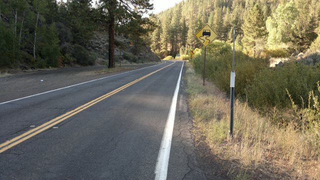
Highway 139 is a bad choice: no hard shoulder, lots of fast-moving traffic and blind curves. Below is a photo of highway 139 at Hayden Hill road, and is typical of conditions on that highway.
Safety
The following are situations where I was forced to use paved roads during my 2014 tour of Modoc county.
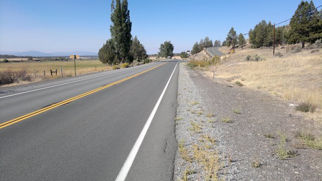
Several miles on Highway 299 west of Alturas, to get to route 73, which is the gravel road leading into the vast northern section of the forest. This road has moderate traffic, open sightlines, a narrow hard shoulder and a wide soft shoulder, as shown below:
Highway 299 between Alturas and Cedarville is a bad idea, since there is little hard shoulder, lots of fast-moving truck traffic and you will be moving very slowly during the steep ascent to Cedar Pass. Much better is route 31, the dirt road which passes Pepperdine campground. Take one day to get to the campground, spend the night there, then finish the journey the next day. You do not need to haul water, since the campground has water faucets.
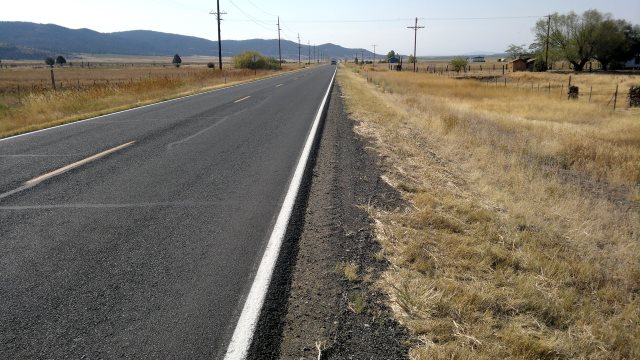
About 20 miles of Highway 395 between Davis Creek and Alturas. No hard shoulder and lots of truck traffic, thus potential for truck squeeze situations (trucks in both lanes, so bicyclist must move onto soft shoulder). I emerged onto highway 395 at Davis Creek after touring the northern Warner mountains. It might be possible to resupply at the small store there, which was still open in 2014, then take route 48 west to get to the Modoc National forest and continue the tour there, eventually returning to Alturas via highway 299, so as to avoid this nasty stretch of highway 395. This is what I will try to do in the future. Below is a photo of highway 395 near Davis Creek:
Route 54 between California Pines development and Alturas. Moderately traveled, with open sightlines and little truck traffic.
Route 56 between Alturas and the Warner Mountains. Very lightly traveled and open sightlines.
Route 1 for about 20 miles between Eagleville and Cedarville, and then another 10 miles between Cedarville and Lake City. Lightly traveled and open sightlines.
Services
Alturas has a True Value hardware, with very limited bicycle parts. In 2014, they were lacking 26" tubes and tires when I was there and also didn't have any bike-specific chain lube, though they did have other lubricants, such as TriFlow in an aerosol can. They also had blue shop towels and citrus degreaser in stock. There is also an auto parts store, which might have citrus degreaser.
ATT prepaid mobile service available in Alturas but not Cedarville, as of October 2016. Supposedly, Verizon service is available in both towns, though perhaps not for prepaid.
Lodging information
Prices below do not include 10% tax.
- Adin - Last Resort Motel, 530-299-3300. (Previously known as Juniper Tree Motel.)
- Alturas - Best Western, 530-233-4111. $90 according to website Aug 2014.
- Alturas - Hacienda Motel, 530-233-3459. Paid $50 in Sept 2015 for one person.
- Alturas - Super8 Motel, 530-233-3545. $70 according to website Aug 2014.
- Alturas - Essex Motel, 530-233-2821. Advertising $46 in Sept 2014.
- Alturas - Frontier Motel, 530-233-3383. Appeared closed as of Sept 2015.
- Alturas - Rim Rock Motel, 530-233-5455. $69 according to website for 1 person, $74 for 2 people.
- Alturas - Niles Hotel, 530-233-3773. $80 according to website Aug 2014.
- Alturas - Wagon Wheel Motel/Restaurant, 530-233-5866 (landline), 530-233-8422 (cellphone), 530-233-5166 (restaurant). Psid $43 in Sep 2016 for one person.
- Bieber - Bieber Motel, 530-294-5454 (100 Highway 299 east).
- Canby - Canby Hotel, 530-233-4242.
- Cedarville - Sunrise Motel, land: 530-279-2161, mobile: 530-260-0112. Half-mile outside town, on highway 299. Paid $50 in Oct 2016 for one person. Has RV park with spot of grassy ground for tent camping, in case motel rooms are all occupied.
- Cedarville - JNR Motel, 530-279-2423. On main street, in middle of town. Paid $55 in Sept 2014 for one person.
- Cedarville - Sunrise Valley Hot Springs, 530-279-2040. 5 miles east of Cedarville. $127 according to website Aug 2014.
- Cedarville - JK Metzker B&B, 530-279-2650
- Cedarville - Cockrell's High Desert Lodging, 530-279-2209. 8 miles south of Cedarville, on highway 299 (at county road 31). $75/$85 for single occupancy weekdays/weekends, according to website Aug 2014.
- Lake City - Cottage at Winje's Farm, 530-279-2371
- Likely - Mill Creek Lodge B&B, 530-233-4934.
Water sources
Warner mountains should have plenty of streams running year-round, and there is water from faucets at Pepperdine Campground in the Warner mountains. In the dry western parts of the Modoc forest, the water mostly consists of filthy reservoirs for livestock, with perhaps some springs running. I would advise carrying all water, other then when in the Warner Mountains. I advise 23 liters capacity. For example, four 6 liter MSR Dromedary bladders in the panniers plus some water bottles in the front triangle. (Dromedaries cannot be filled to the top without spilling, so actual capacity of the 6 liter size is about 5.5 liters). Make sure your urine runs clear at least once per day. Kidney stones are painful—I'm speaking from experience here.