Hiking in Spain - GR7 Trail Guide
All content (other than maps) copyright © 2010-2026 Frank Revelo, www.frankrevelo.com, United States copyright office registration number TX-7931345, maps copyright © OpenStreetMap and Frank Revelo
Note that I have not hiked GR7 west of Niguelas since 2014 or north of Benagéber since 2024, so my GPX may be wrong in these areas. See Hiking in Spain page for alternative GPX sources.
Torrential floods in Oct 2024 washed out parts of GR7 south of Requena. As of April 2025, trail crews have cut and waymarked new GR7 from start to washout to Las Moratillas, 15km east of Requena on A3 autoroute. Presumably, official GR7 from Las Moratillas to Siete Aguas and Chera is okay, since no deep canyons in this area. But I can't say for certain, since I detoured to/from Requena to resupply, using roads shown on maps. In any case, my GPX was already wrong in this area, since GR7 rerouted near Chera sometime prior to 2024.
According to internet report, footbridge over Turia river north of Benagéber washed away in Oct 2024, along with much of trail on either side. So in 2025, I abandoned GR7 at Benagéber and followed highway to Tuéjar (which has hotel and supermarket), then dirt roads north along Río Tuéjar/Chelva and Rambla de Arquela until intersection with GR37 southeast of Alpuente, then more dirt roads (occasional GR37 waymarks) to Yesa, La Cuevarruz, Arcos de las Salinas, then PR-TE7 to Manzanera, Rubielos de Mora and finally Mora de Rubielos and intersection with GR8 (see Hiking in Spain - GR8 Trail Guide).
Be sure to check main Hiking in Spain and Hiking in Europe pages for additional information and links.
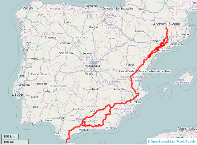
GPX track here (GR7, including southern and northern variants in Andalucía, GR7.9, GR171, part of GR172, GR174, GR175, Estels del Sud, plus waypoints showing locations of hotels/stores/fuentes). View in Google maps here.
Here is my trip report of parts of the GR171 and GR172 in Catalonia in 2013.
Here is my trip report of the GR7 between Ronda (Andalucía) and Andilla (Communidad Valenciana) in 2014.
Other trip reports: John Hayes, Amy Lauterbach, Juan Holgado.
Official hiking organizations:
- Fedederació d’Entitats Excursionistes de Catalunya.
- Federació d'Esports de Muntanya i Escalada de la Comunitat Valenciana.
- Federación de Montañismo de la Región de Murcia.
- Federación Andaluza de Montañismo.
Prices below assume low season (everything except Christmas, New Year, Semana Santa, holidays, July, August). Sometimes late June, early September and weekends during spring and fall are also considered high season. Pricing information from hotelsearch.com, toprural.com, and ecoturismorural very unreliable.
Whether or not Saturday is considered high season for pricing, that day is usually the busiest at most hotels. Be prepared to camp then if you don't have a reservation.
Most towns have a water fountain. Stores in small towns face severe competition from a combination of daily fruit/bread trucks and delivery by hypermarts (ordering by internet) and many can be expected to shut down in the future. Bakeries (horno or panadería) sometimes also sell non-perishable food (canned goods, chocolate, etc). Stores and bakeries may have limited hours. It is best to always carry some extra trail food (biscuits, pan de molde, etc).
As of 2016, quantity of Airbnb.com listings is rapidly increasing for rural areas of Spain, so be sure to check that site. Booking.com is also increasingly being used by smaller hotels. But I would avoid using booking.com to make reservations and especially to pay with smaller hotels, since they often have internet problems. Sometimes booking.com shows vacancy in small hotel but either hotel is closed or no vacancy. So just use it to get availability and price range of rooms.
Quick jump
Catalonia
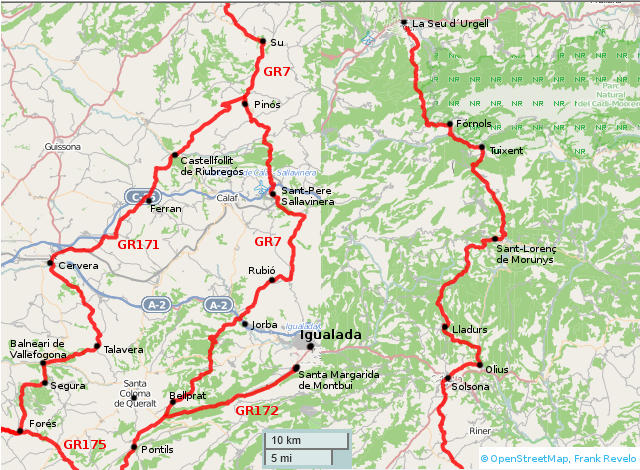
Balneari de Vallfogona
- Hostal* Fangara, 977 880 026.
- Hotel*** Balneari de Vallfogona, 977 880 025. 60€ individual, 102€ double from March through May, according to website Jan 2014.
- Hotel**** Regina & SPA, 977 880 028.
Bellprat
- Fuente below church plaza, to side
- Hotel Comtes de Queralt in Santa Coloma de Queralt (5km west of GR7), 977 881 924 (35€ in 2011 for single occupancy, according to another GR7 journal)
Cervera
- Hostal La Savina, 973 531 393, 652 679 426. 30€ single / 60€ double occupancy, according to website Jan 2014. Paid 35€ for single occupancy of double room with bath in May 2010.
- Hostal Bonateca, 973 530 325, 973 535 319.
- Hostal** Bonavista, 973 530 027.
- Casa rural El Celleret, 973 533 908, 605 780 152.
- Casa rural La Casa da Baix, 678 718 312. 60€ double occupancy of stuido, according to website June 2013.
- Sagrada Familia Albergue de Peregrinos, 973 530 805.
Coma i La Pedra, La
- Fonda Cal Nin, 973 492 378
- Hostal Fonts del Cardener, 973 492 377
- Hostal Ca la Mari, 973 299 270
Fórnols
- Càmping Molí de Fórnols, 973 370 021
Igualada
- Hotel Canaletes, 938 032 750
- Hotel Ciutat Igualada, 938 066 150. 52€ individual, 59€ double occupancy on weekdays according to website Jan 2014.
Jorba
- Fonda Jorba, 938 090 008
Lladurs
- Casa Angrill, 973 299 096
- Casa de Pagès Corral, 973 480 303
- Casa de Pagès Flotats, 973 482 390
- Casa de Pagès El Pla de Montpolt, 973 480 107
Olius
- Hotel Pi de Sant Just, 973 480 700
- Hotel Molí del Pont, 973 299 346
Pinós de Solsonès
- Casa de Pagès Cal Miralles, 938 691 367
- Hostal/restaurant bar de Pinós 973 473 062
Pontils
- Hotel** Casa Guimerà, 606 365 200.
Sant Llorenç de Morunys
- Hotel Castor, 973 492 102
- Hostal** Casa Joan 973 492 055
- Hotel** El Monegal 973 492 369
- Hostal Piteus, 973 492 340
- Hostal La Catalana, 973 492 125
- Fonda restaurant Morunys, 973 492 342
- Pensió Casa Joan, 973 492 055
- Càmping Morunys, 973 492 213
- Càmping Cal Pampa, 973 492 242
Seu d'Urgell, La
- Informació Turística, 973 351 511.
- Càmping Envalira, 973 351 035.
- Alberg de Juventut, 973 353 897.
- Pensió Duc d'Urgell, 973 352 195.
- Hostal* la Glorieta, 973 351 045.
- Hostal Jové, 973 350 260.
- Hotel* Avenida, 973 350 104.
- Hostal Ignasi, 973 351 035
Solsona
- Fonda* Pilar, 973 480 156, 973 481 933, paid 14€ for single with shared bath in May 2010.
- Hotel*** La Freixera, 973 484 262, 629 723 757. Only 5 rooms, very swank. Singles 64€ low season, doubles 88€ low season, 99€ high season, breakfast and IVA included. High season includes weekends.
- Hotel*** Sant Roc, 973 484 003. (edge of casco antiguo). 52€ individual, 91€ double occupancy, according to website Jan 2014.
- Hotel*** Gran Sol, 973 480 975 (about 2km outside town).
- Hotel** Crisami, 973 480 413 (about 1km outside town).
- Hotel** Solsona Centre, 973 484 340.
- Càmping el Solsonès, 973 482 861.
- Habitacions M/D, 973 482 540.
- Alberg de Joventut Can Mascaró, 973 481 515.
Su
- Hostal** El Forn de Su, 973 480 618.
Tuixent
- Hostal Custodi, 973 370 033
- Alberg Can Cortina, 973 370 224
- Habitacions Can Ferragetes, 973 370 034
- Habitacions Cal Fuster, 973 370 002
- Habitacions Ca l'estevet, 973 370 001
- Restaurant la Rectoria Vella, 973 370 198
- Refugi Coll de Port, 973 298 242
- Refugi de l'Arp, 973 370 036
Turismo en Catalunya has some accomodation info.
More accomodation info for GR175 at La Ruta del Cister.
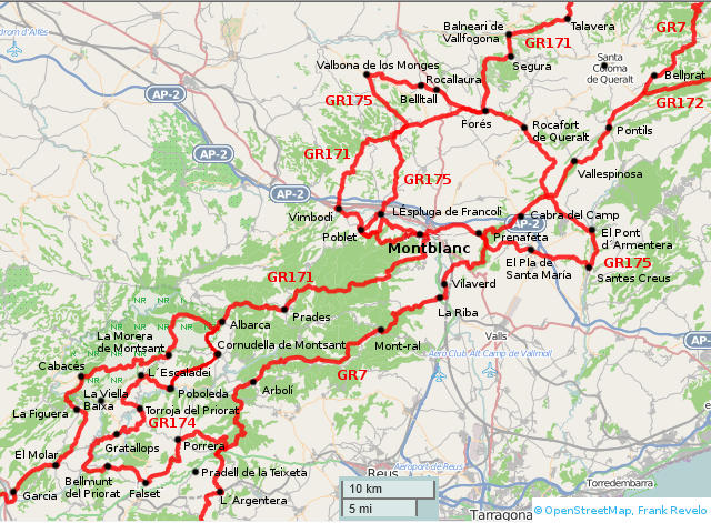
Arbolí
- Hostal L'Hostalet, 977 816 171. As of 2010, 40€/person, half-pension for 55€, single supplement 12€.
- Refugi Arboli, 630 968 507. 15€ for dorm bed, according to website Jan 2017 (however, website pricing page dated 2012).
Albarca
- Casa Rural Pla del Castell, 659 863 185, (town fuente in front yard)
- Refugi Montsant, 660 660 721, open weekends with reservation.
Balneari de Vallfogona (see above)
Bellmunt del Priorat
- Pensión** Cal Quel, 977 830 277.
Bellprat (see above)
Belltall
- L’Hostalet, 977 892 839. About 2km north of Forès, on the T-222 road.
- Hostal** Feliuet, 977 892 705, 977 892 753.
Cabacés
- Store
Cabra del Camp
- Restaurant.
Cornudella de Montsant
- Fonda el Racó*, 977 821 032.
Escaladei
- Pensión** Els Troncs, 977 827 158.
Espluga de Francolí, L'
- Oficina de Turisme, 977 871 220.
- Fonda** Les Disset Fonts, 977 870 302.
- L'ermita (acampada i habitacions), 977 870 634.
- Hotel*** Masia del Cadet, 977 870 869.
- Hotel* Villa Engracia, 977 870 308. 49€ double according to website Jan 2014.
- Hotel** del Senglar, 977 870 121.
- Fonda* Francolí, 977 871 216. 43€ individual, 69€ double with breakfast, according to website Jan 2014. Possible discounts for Monday through Thursday.
- Alberg de Joventut Jaume I, 977 870 356.
Falset
- Patronat de Turisme, 977 831 139.
- Pensión* Nacional, 977 830 157. Paid 27€ for single occupancy of double room with shared bath in March 2010.
- Hotel**** Sport, 977 830 078. 80€ for double occupancy, according to website Jan 2014.
Figuera, La
- Zona municipal d'acampada, 977 400 638.
Garcia (see below)
Gratallops
- Hotel*** Cal Llop, 977 839 502. 90€ individual, 112€ double occupancy, according to website Jan 2014. 20% discount Sun-Thu.
- Hostal** La Font, 977 839 172, 977 839 279.
- Hostal** Elvira, 977 839 185.
- Hostal La Cassola, 977 262 146.
Montblanc
- Fonda** Bohèmia Riuot, 977 875 145, 629 319 408, Pleta, 23 (near Vilasauba €and Riuot Alt). Paid 25€ in May 2013 for single occupancy of double room with bath. Possibility of noise from other guests in hall when fully occupied. 45€ for double, according to website Jan 2014.
- Fonda** Àngels, 977 860 173, Plaça dels Àngels, 1. Paid 35€ in May 2010 for single occupancy of double room with bath. Can be noisy in evening from guests in restaurant. 40€ for double occupancy, according to website Jan 2014.
- Fonda** Cal Blasi, 977 861 336, 689 413 460, Alenyà, 11. 74€ for double, according to website Jan 2014.
- Hotel** Viaurèlia, 977 861 790, 646 373 292, Dionis Mestre, 3. 65€ for double, 45€ single occupancy, according to website Jan 2014.
- Also, apartments and houses for rent on short-term basis, visit oficina de turisme, 977 861 232.
Mont-ral
- Refugi Musté Recassens, 646 297 447. 12€ per person for dormitory accomodation, 27€ per person for half-pension, according to website Jan 2014.
- Hotel** La Massada, 977 767 035
Morera de Montsant, La
- Store.
- Hotel*** El Balcó del Priorat, 977 827 211, 977 827 088.
Poblet (see Vimbodí below)
Poboleda
- Hostal Antic Priorat, 977 827 606.
- Pensión** Popoletus, 977 827 010, 977 827 302.
Pontils (see above)
Porrera
- Hotel** Els Pampols, 977 828 382. 85€ double occupancy, according to website Jan 2014.
Pradell de la Teixeta (on the N-420, a few km southwest of where the GR7 crosses that highway)
- Pensión** Can Ciurana, 977 828 210.
Prades
- Restaurant La Botiga, 977 868 321. Paid 30€ in Mar 2013 for single occupancy of double with bath.
- Hotel* Espasa, 977 868 023.
- Càmping Prades, 977 868 270.
Prenafeta
- Hotel* Els Pins, 619 712 059. Paid 25€ in Mar 2013 for single occupancy of double room with bath. 60€ for double occupancy according to website Jan 2014, special offer of 50% discount weekdays Feb through April 2014, with online reservation.
Riba, La
- Zona d'acampada, 977 876 114.
Rocallaura
- Hostal L'Antic Balneari de Rocallaura, 973 330 214, 977 601 734. Simple rooms from photos on website, no prices listed.
- Hotel**** Balneari de Rocallaura, 973 330 632. 53€ double occupancy weekdays, according to website Jan 2014.
Santes Creus
- Hostal** Grau, 977 638 311, 977 639 127.
Torroja del Priorat
- Hotel**** Abadia del Priorat, 977 054 030.
Vallbona de las Monges
- Hospederia Monàstica de Santa Maria de Vallbona, 973 330 266, 618 876 004. Communal meals made from from the orchards of the nunnery, simple rooms, optional participation in the services. No mention of prices or whether this is for both sexes or women only.
- Hostal Rocallaura, 973 330 214.
Vallespinosa
- Hotel** Casa Guimera, 977 266 293. Hotel appears closed as of Nov 2016, according to another hiker.
- Seasonal restaurant.
Viella Baixa, La (La Viella Alta is on the GR174, use road to get to La Viella Baixa)
- Pensión** El Racó del Priorat, 977 839 065.
Vilaverd
- Hotel*** Cal Maginet, 646 602 097. 80€ double occupancy with breakfast, according to website Jan 2014.
Vimbodí
- Hotel** Monestir de Poblet, 977 870 089. 40€ individual, 49€ double occupancy, according to website 2014.
- Hotel** El Fonoll, 977 870 333. 40€ individual, 70€ double, without meals, according to website Jan 2014.
- Casa Rural Castell de Riudabella, 977 878 040.
- Hostal** Rural Can Mortés, 616 017 933, 977 878 375.
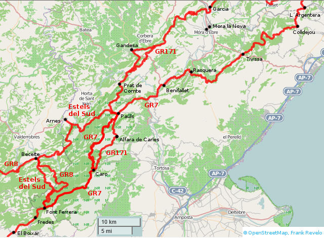
Alfara de Carles
- Residència-casa de pagés Can Ricard, 977 455 015.
- Pous de la Neu, 977 262 757.
Arnes
- Can Barrina, 977 435 137.
- Hotel** Hort de Fortunyo, 977 435 155.
- Hotel**** Vilar Rural d'Arnes, 977 435 737.
Beceite (see GR8 trail guide)
Benifallet
- Fonda El Chiringuito, 977 462 002.
- Hotel** Pepo, 977 462 200. 45€ and up double occupancy, according to website Jan 2014.
- L'Antiga Estació de Benifallet, 932 194 152. Hostel with dormitory accomodations in rooms with four beds, 28€ per adult. 15€/person to sleep in their tent and mattress, your own sleeping bag, breakfast included.
Caro
- Refugi Caro, 977 267 128, 617 808 816. 36€ per person for dormitory accomodation in rooms of 4 beds, including evening meal and breakfast.
Colldejou
- Hotel** Aire de Colldejou, 977 054 921. Hotel closed in Nov 2016, according to another hiker.
- Restaurant and small grocery with limited selection of food.
Font Ferrera (intersection with GR8)
- Refugi, 977 588 668, 647 847 105.
Gandesa
- Fonda Serres, 977 421 025, 679 181 584. Paid 20€ for single with shared bath in March 2013. Fonda operated by the Chinese bargain shop on the ground floor.
- Hostal* Piqué, 977 420 068.
Garcia
- Store, easy walk to Mora d'Ebre via GR99 (right bank of río Ebro)
- Zona municipal d'acampada, 977 400 638.
Mora d'Ebre
- Hostal Creu, 977 400 707. 36€ individual, 55€ double occupancy, according to website Jan 2014.
- Hostal 7 de Ribera, 977 403 426.
Mora la Nova
- Hostal Barcelona, 977 400 336.
- Hostal Fontdemora, 977 400 033.
- Hostal Mas Subirats, 977 402 854.
- Hotel** Mora Park, 977 400 929.
Paüls
- Ca Les Barberes, 977 492 330, 669 832 930, on the GR7 itself at the edge of town. Paid 25€ in March 2013 for single occupancy of double room with bath and great view. 35€ individual, 50€ double occupancy according to website Jan 2014.
- Casa de Pagès Pamela, 977 704 183.
Prat de Comte
- Restaurant Ca L'Àngels, 977 428 309. Paid 20€ for single occupancy of double room with bath in March 2013. Would be 40€ for double occupancy.
- Alberg, 977 428 284
- Zona d'acampada municipal, 977 428 284
Tivissa
- Fonda Tossa, 977 418 001. 27€ as of Nov 2016, according to another hiker.
- Bar Tivissa, 977 418 131.
- Hostal Tivissa, 977 418 020. 45€ double occupancy according to website Jan 2014.
Communidad de Valencia
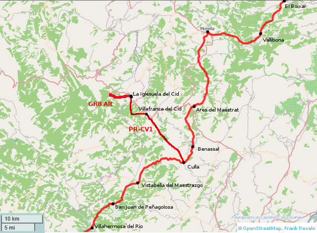
Ares del Maestre
- Panaderia.
- Hotel** Ares del Maestre, 964 443 007. 25€ single, 40€ double occupancy, according to website Jan 2014.
Benasal (or nearby Font d'en Segures)
- Stores.
- Hotel** La Piqueta, 964 444 099, 964 431 048, 679 008 465. 25-33€ single, 42-55€ double occupancy, according to website April 2016. Paid 33€ single occupancy in April 2019.
- Hostal La Catalana, 964 431 199, 676 805 941. 30€ single, 60€ double occupancy, according to website April 2016. Font d'en Segures.
- Hostal Los Pinos Benassal, 964 431 052, 964 431 311. 42€ double occupancy, according to website June 2013. Possibly open only in summer. Font d'en Segures.
- Hotel Roig, 964 431 087, 964 431 112, 635 536 583, 651 906 031. 29€ single, 47€ double occupancy, according to website June 2013. Possibly open only in summer. Font d'en Segures.
- Hotel La Castellana, 964 444 017. 60€ single, 70€ double occupancy, according to website April 2016. Font d'en Segures.
- Hotel Novella, 964 431 094. 50€ singly, 66€ double occupancy, according to website April 2016. On GR7, just west of Font d'en Segures.
Culla
- Stores.
- Advertisements for apartments for rent.
Fredes
- Restaurant, 977 729 022. Offers apartments for rent.
Morella
- Hotel El Cid, 964 160 125. 30€ single / 44€ double occupancy weekdays, 32€ single / 53€ double occupancy weekends, according to website April 2016.
- Fonda Moreno, 964 160 105. 38€ single / 60€ double occupancy, according to website June 2013.
- Hostal Muralla, 964 160 243. 27€ single, 40€ double occupancy, according to website April 2016. Paid 30€ single occupancy in May 2019.
- Hotel del Pastor, 964 161 016.
San Juan de Peñagolosa
- Fuente behind church.
Vallibona
- Store.
- Hostal* La Carbonera, 964 172 000, 666 203 216. Paid 25€ single occupancy in April 2016.
Villahermosa del Rio
- Hostal Ruta de Aragon, 964 382 641. Paid 35€ for single occupancy in May 2024.
- Hostal El Palamor, 964 382 509, 616 162 815. 60€ for single occupancy half-pension, according to webiste June 2013.
- La Posada Del Río Carbo, 680 622 077, 659 612 112. 75€ for double occupancy, according to website June 2013. About 2km north of Villahermosa on GR7 in Río Carbo canyon.
Vistabella
- Stores.
- Fuente 1KM north of Vistabella says non-potable but is potable.
- Bars might offer rooms for rent.
- Casa Rural Cal Puento, 964 389 025, 658 091 498.
- A un Pas del Cel, 964 389 141, 659 448 321. 78€ double occupancy half-pension, according to webiste June 2013.
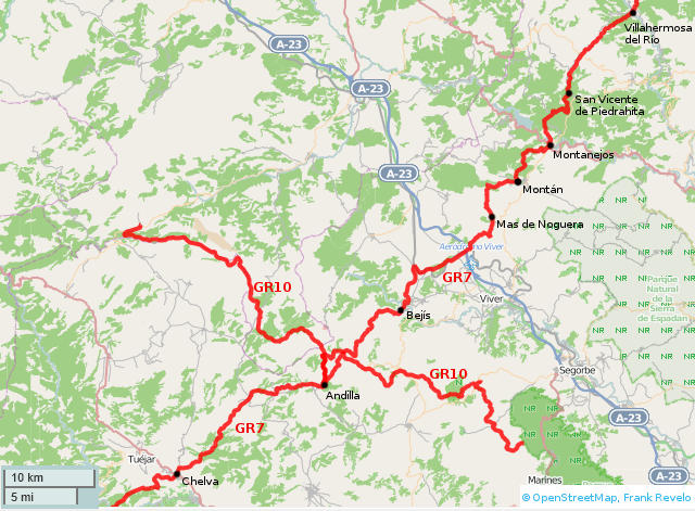
Just north of Mas de Noguera is a very overgrown section of foot trail, including thorns. I recommend staying on the road, which adds about 2km distance.
Andilla (intersection with GR10)
- Ayuntamiento
- Bar.
- Casa Racó de L'Om, 629 290 565. 46€ single / 57€ double occupancy, according to website June 2013.
- Casa Muralla, 647 287 102, 650 629 359.
Bejís
- Stores.
- Fonda Tren Pita, 964 120 164. Paid 25€ for single occupancy in April 2017. When I called in May 2022, man who answered said they no longer rent rooms.
Chelva
- Tourist office.
- Supermarkets.
- La Posada de Chelva, 962 100 104, 665 559 170. On the highway. 30€ single / 45€ double occupancy, according to website April 2018. Paid 30€ for single occupancy April 2019. If owner out of town, go to Mat 27 bar (about fifty meters away, on same side of street), where they can arrange to let you inside. Person who answered phone said hotel closed when I called in April 2022, and only other lodging in town was casas rurales. No list of these casas rurales at tourist office website. In April 2023, talked to owner of bar across from hotel and he confirmed hotel no longer operating.
Tuéjar (about 5km from Chelva)
- Hotel Álvarez, 961 635 282. Paid €50 for single occupancy in April 2025.
Mas de Noguera
- Fuente.
Montán
- Hostal Pilar, 964 131 094. Paid 30€ for single occupancy in April 2019.
Montanejos
- Hostal Casa Ovidio, 964 131 309. 658 622 711. Paid 45€ for single occupancy plus breakfast in Apr 2024.
- Hotel** Gil, 964 131 380. 25€ single, 50€ double occupancy, according to website April 2016.
- Hotel** Xauen, 964 131 375. €40 and up for single occupancy, according to website April 2023.
- Hotel** La Valenciana, 964 131 062.
- Hotel*** Spa Rosaleda, 964 131 079.
- Hotel Casa Palacio, 964 131 293. 36€ single / 52€ double occupancy, according to website April 2016.
- Apartamentos Campuebla, 964 131 074, 629 673 522.
- Albergue El Refugio, 964 131 317. 19€-24€ single occupancy in dormitory, according to website April 2016.
San Vicente de Piedrahita
- Store.
Villahermosa del Rio (see above)
Torás (several km from Bejís, not shown on map above)
- Stores.
- Hotel Antonio Ponz, 639 306 815. Paid €50 single occupancy in May 2022.
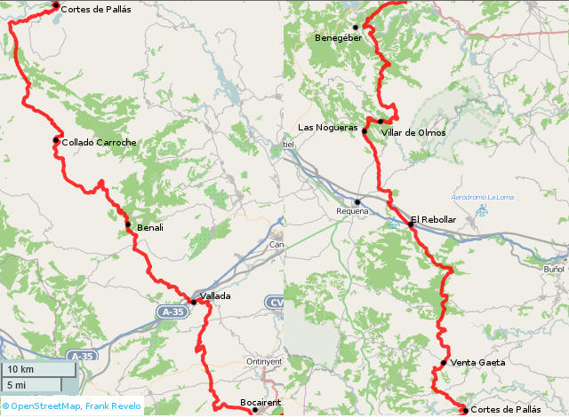
Benagéber
- Rooms at bar.
- Albergue, 963 421 457.
- Casa Rural La Cambrilla, 651 009 429. 120€ for 2 bedroom apartment, according to booking.com Jun 2014.
Benalí
- Casas de Benalí, no telephone as of April 2019, but quick email response. €45 single, €65 double occupancy according to website in April 2019. May have special rates for hikers, contact owner. Unlikely to be fully occupied in March/April (other than Semana Santa), but if so, can camp nearby. Stayed here in April 2019.
Collado Caroche
- Reliable water (fuente that has always been running in April when I pass through, plus reservoir in case fuente dry). Distance from Vallada to Collado Caroche 56km. Casas de Benalí open most of year. If closed, fuente outside (marked by sign on road) runs in wet months. I always pass in April and fuente normally running then, though sometimes very slowly in dry years, with spring box full of clean water. Possible to email Casas de Benalí in advance to confirm fuente has water. If Casas de Benalí closed and dry season, then drink 2L at Vallada or Collado Caroche and carry at least 6L water (assuming mild temperatures and man weighing 75kg) to cover this usually dry stretch in 2 days. Some fire fighting reservoirs between Vallada and Collado Caroche which may have water, though I've never visited them myself because they are several hundred meters detour from road. Distance from Collado Caroche to Cortes de Pallás 32km. Total distance Vallada to Cortes de Pallás 88km, so carry 3 days food, or 2 days if eating at Casas de Benalí.
Cortes de Pallás
- Two food stores: one with fresh fruit and vegetables, one with fresh bread. As of April 2024, store with fresh bread closes Mondays, other store open until 14:00.
- Hostal Casa Fortunato, 962 517 026. c/Doctor Sánchez Ursáiz, 6 (south of bridge from church). Paid 18€ for single occupancy of double with shared bath in April 2019.
- Hostal Ca' La Conchin, 608 466 473, 644 858 618. c/Doctor Sánchez Ursáiz, 8 (south of bridge from church). Paid 35€ for single occupancy in April 2023.
- Casa Rural Las Anas, 606 750 800. C/Arriba, 7 (street just north of church plaza). Paid €40 for single occupancy in April 2024.
- Bars on main plaza may also offer rooms for rent.
Nogueras, Las
- Fuente
Rebollar, El
- Área de servicio El Rebollar (hostal*, restaurant), 962 300 982. 35€ single, 60€ double occupancy, according to booking.com Jun 2014. No vacancies when I stopped by in April 2014. Prior to 2020, there was mini-mart attached to gas station, but gone in 2022 because restaurant objected to food sales.
Requena
- Distance from Cortes de Pallás to Venta Gaeta is 15km. Another 36km to El Rebollar. Another 9km to Requena via service road south of autovía. So about 60km or two long days or three short days between Cortes de Pallás and Requena. There may be fuentes between Venta Gaeta and El Rebollar, however I always carry sufficient water for this stretch (definitely water in Río Mijares, but that requires treatment).
- Friday before Good Friday is local holiday in Requena (Viernes de Dolores).
- Hotel Avenida, 962 300 480, 962 300 590. c/San Agustín, 10 (center of town). Paid 37€ single occupancy in April 2024.
- Hotel*** Patilla Ciudad de Requena, 962 301 021. East end of town on N-111 @ Avenida Nicanor. Paid 45€ single occupancy in April 2023.
- Hostal Alojament La Tinaja, 962 349 698. c/Cristo, 21 @ Plaza Albornoz (medieval town). 35€ single, 45€ double occupancy, according to website Jun 2014.
- Hotel Doña Anita, 962 305 347. Plaza Albornoz (medieval town). 42€ single/double occupancy, according to website Jun 2014.
- Hotel La Villa, 962 301 275. Plaza del Albornoz (medieval town).
- Casa Petra, 962 305 509, 676 797 314. Calle de la Purísima, 12 (medieval town). 45€ double occupancy, according to website Apr 2016.
- Casa Lucía, 606 936 495. Calle Santa María, 33 (medieval town).
- Apartment Ksota. Paid €71 through booking.com in April 2025. Middle of Easter week, so many hotels were full.
- Casa Collada, 962 304 421. Calle Collada, 9 (medieval town).
- Casa Rocío, 661 194 303. Calle Fortaleza, 10 (medieval town).
- Casa Isabel, 665 418 361. Calle Pintor Martínez Checa, 1 (slightly east center of town).
- Hostal San José, east of town on N-111.
- Hotel** Sol II, 962 300 058. Carretera de Madrid, km 272 (several km west of town). 30€ single, 45€ double occupancy, according to booking.com, Jun 2014.
Vallada
- Supposedly, someone at one of the smaller supermarkets has cheap rooms for rent.
- Apartamentos Giners, 962 258 100, 629 910 687, 669 640 740. c/Mig, 22 (near the Church). Paid 50€ for single occupancy of studio in Mar 2016 on a Thursday (higher rates on weekends). Apartment also listed on AirBnb.
- Casa Rural Casa Peseta, 658 93 72 85, 54 Avenida Guardia Civil. Paid €50 via booking.com in April 2024. Paid €45 via direct booking in April 2025.
Venta Gaeta
- Fuente, bar, restaurant.
- Casa Rural El Mirador, 607 721 515.
- 5km west of Venta Gaeta in Casa Rural La Alborada, 677 655 952, casaruralalborada@yahoo.es.
Villar de Olmos
- Fuente
Viñuelas (5km west of Venta Gaeta along paved road)
- Casa Rural La Alborada, 677 655 952, casaruralalborada@yahoo.es.
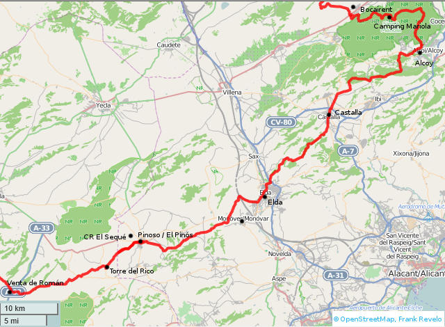
Alcoy
- Hostal Savoy, 965 547 272. c/Casa Blanca, 9. Paid €50 single occupancy in Apr 2025.
- Hotel*** Reconquista, 965 330 900. 47€ single, 55€ double occupancy, according to website Jan 2014.
- Apartamentos Alcoy, 676 998 423. c/Sant Joan Ribera, 70 (south of park del viaduct). Furnished apartments. 52€ double occupancy, according to booking.com Oct 2016.
- Hotel**** AC Marriott, 965 333 606. c/Colón, 1. 66€ double occupancy, according to website Oct 2016.
- Casa rural La Safrarera, 639 681 717. Partida Llacune, 15.
- Casa rural Bona Aires, 660 666 768. Partida Llacune, 6.
- Masía La Moto, 966 549 370. Carretera Font Roja, km 5.
Bocairent
- Tourist Office, 962 295 062.
- Casa Baretta, 962 905 235, 678 575 490. Plaza Sant Vicent, 12. 30€ single, 40€ double occupancy, according to website Feb 2014.
- Casa Mon Mossen, 654 113 225, 653 786 873. 50€ double occupancy, according to website Jun 2014.
- Casa Sant Vicent, 660 736 774. 60€ double occupancy, according to webiste Jun 2014.
- Casa El Canter, 962 350 263, 699 328 779, 665 544 588. 64€ double occupancy, according to website Jun 2014.
- L'Agora Hotel Bocairent, 962 355 039. 50€ single / 60€ double occupancy weekdays, 66€ single / 80€ double occupancy weekends, according to website June 2013.
- Hotel L'Estacio, 962 350 000. 81€ double occupancy weekdays, 99€ double occupancy weekends, according to website June 2013. Appeared closed when I stopped by April 2014.
- Casa La Llar de Laura, 639 520 916. 140€ double occupancy, according to website Jun 2014.
- Hotel**** Ferrero, 962 355 175. Partida Maset de Chiner. 200€ or more double occupancy, according to website Jun 2014.
- Casa Mirador, 678 575 488, 645 177 888.
- Casa Mariola, 962 351 125. c/Mossen Hilari, 33-35.
- Camping Villa Carmen, 650 202 156, c/de la via (south of highway, then northeast for 500m), 5€/tent + 5€ adult.
Camping Mariola
- Camping Mariola, 962 315 160. Just north of Font Mariola. Campground, bar, restaraunt store. Bungalows for 55€ (2 nights minimum on weekends), camping 5€/adult + 5€/tent.
Castalla
- Tourist Office.
- Hotel*** Don Jose Castalla, 965 561 505. Avenida Ibi, 50. 45€ single, 61€ double occupancy, according to website Jun 2014. Quoted me 40€ for individual occupancy in Apr 2014.
- Casa Rural Ca Sole, 646 647 876. c/San Isidro, 29. 30€ single, 35€ double occupancy, according to website Jun 2014. Paid 25€ for single occupancy of very nice double room in April 2014.
- Hotel Rural Caseta Nova, 666 533 397. Carretera Ibi-Castalla, mid-way between Castalla and Ibi, a few km outside Castalla. Paid €36 in Apr 2025 for single occupancy through booking.com.
- Hotel Onil, 966 556 044. A few km north of Castalla, along the CV-8153 highway.
Elda
- Hostal Carrizo, 965 381 007, 618 775 077. c/Pedrito Rico, 65 (junto mercado central). Paid 55€ for double room in Apr 2024 through booking.com. Paid €40 for single room in Apr 2025 outside booking.com.
- Hotel Santa Ana, 722 135 632. c/Iglesia, 4 (frente ayuntamiento). Paid 36€ for single occupancy of double room in April 2019. In April 2023, man working at hotel told me it was no longer nightly hotel but rather studios for rent for longer stays. Affiliated with Hotel Sant Bonifaci.
- Hotel Sant Bonifaci, 965 391 391, 965 392 392. Avenida de Madrid in Petrer (just east of Elda).
- Hotel AC Elda by Marriott. 966 981 221. Avenida de Chapí, 38 (plaza de la ficia). 68€ double occupancy, according to website Jun 2014.
- Hostal Residencial Elda, 965 380 556. Appears permanently closed.
- Habitaciones Petrer. 658 450 500. C/ Rafael Duyos 8, Petrer (1km east of Elda). Paid 30€ single occupancy in Mar 2018 (this was for Viernes Santo, rates might be different outside Semana Santa).
- Apartamento Completo in nearby Monóvar. Paid €50 for single occupancy in Jul 2020 through booking.com.
Pinoso / El Pinós
- Hostal La Cañada, 965 477 131, 620 344 073. c/Badén Ricolucas, 14. Paid 36€ for single occupancy in Mar 2025.
- Casa Rural El Sequé, 649 282 844, 690 655 274. 2km northwest of Pinoso (take highway west from Pinoso for 2km, direction Jumilla, turn north onto a paved road, which should have a sign for El Sequé, 500m more to the caserío). 30€ single, 50€ double occupancy, according to website Jan 2014.
Venta Roman
- There used to be a gas station with restaurant here, but everything was closed when I passed through in Mar 2016, apparently permanently. There are some houses nearby where it might be possible obtain water, but also huge packs of dogs running loose in yards of these houses. 55km from Cieza to Pinoso, about 45km between Cieza and Torre del Rico. Assuming you don't want to rely on water from houses at Venta Roman and plan to camp, then drink 2L with breakfast and carry 6L out of Cieza/Torre del Rico in hot weather, 3L in cool weather (for man weighing 75kg).
Murcia
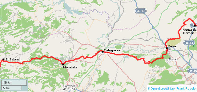
About 97km from El Sabinar to Cieza. Possible to hike in 2 long and 1 short days, staying in hotels in Moratalla and Calasparra, but I prefer 5 short days: camp 2 nights, hotel in Calasparra, camp again. After drinking 2L with breakfast, carry 6L water between Calasparra and Cieza in warm weather (for man weighing 75kg), 4L sufficient in cool weather.
Alternative route follows dirt roads east from GR7 to Abarán, buy food there, continue east to hotel Mesón del Moro on highway N301. Next morning, follow route MU22A, highway N344 and various minor roads north until intersection with GR7 at location marked Casa del Alto on CNIG maps. About 42km total for this route from Mesón del Moro to Hostal La Cañada in Pinoso.
Calasparra
- Hotel*** la Merced, closed as of Mar 2016, according to tourist office.
- Hospedería Constitución, 968 720 801. c/Mayor. 65€ double occupancy, according to booking.com Jun 2014.
- Hotel Primavera, 868 081 599, 687 705 674. Avda Coop del Campo Virgen de la Esperanza (near Día and Consum supermarkets). Paid 45€ for single occupancy in March 2025. Paid €55 for single occupancy in March 2024 through booking.com because Semana Santa.
- Camping Los Víveros, 968 735 889, 657 941 750. 3km west of Calasparra.
- Albergue Las Lomas, 968 723 000.
- Casa Rural Casa del Roble, 968 653 132.
- Hotel Argos, 968 720 707. 5km west of Calasparra, on RM-714. 39€ single, 48€ double occupancy, according to website Oct 2016.
- Casa Rural El Corralazo, 677 822 312. c/Cieza, 28.
- Casa Rural Palmera Moya, 660 031 879. Paraje "La Palmera".
- Casa Rural Los Forros, 628 039 472.
- Casa Rural La Luz, 968 723 000. Paraje "La Luz".
- Casa Rural La Luz Azul/Amarilla, 968 720 801. Paraje "La Luz".
Cieza
- Hospedería Casa de la Campana, 968 454 581. Located 5km west of Cieza (carretera to Ginete). 80€ individual, 90€ double occupancy, according to website June 2020. Paid 72€ through booking.com, after 10% "genius" discount, in June 2020.
- Hospedería San Sebastián, 868 961 868. c/San Sebastián, 21 (center of town). Paid 55€ single occupancy Mar 2019. Website as of June 2020 says 55€ single, 77€ double. Closed when I called in June 2020.
- Albergue Rural Atalaya, 606 372 701.
- Hotel Mesón del Moro, 968 770 225. Carretera Madrid-Cartagena, km 359, Abarán. About 6km southeast of Cieza. Paid 44€ single occupancy in Mar 2024 through booking.com. Paid €38 without booking.com in Mar 2025.
Moratalla
- Pensión* Reyes, 968 730 377, 690 237 217. c/Tomas el Cura, 7. Paid 20€ for single room with double bed shared bath in 2014.
- Pensión** El Claustro, 968 433 123, 670 455 543. c/Casa Cristo, s/n.
- Hospedería* La Tejera, 968 706 261, 968 730 000, 658 141 016. 2km west of Moratalla, on the GR7. 49€ double occupancy, according to website June 2014.
- Camping La Puerta, 968 730 008. About 5km west of Moratalla, on the GR7. 8€ for single person with tent, according to website June 2013.
- Hotel*** Cenajo. Closed as of 2014, according to website.
- Finca La Celada, 968 707 742, 699 477 298. 3km west of Moratalla, on GR7, on highway.
- CR Puerto Rico, 659 480 110. 3km west of Moratalla, on GR7, on highway.
- Molino del Camino, 646 606 807. 3km west of Moratalla, on GR7, on highway.
Sabinar, El
- Several stores and panadería in town.
- Pensión El Nevazo, 968 738 052, 690 067 010. Paid 25€ for single occupancy in Mar 2025.
- Casa Pernías, 968 726 311, 680 628 898. 81€ single / 107€ double occupancy, according to website Jan 2014. Located about 4km east of El Sabinar, at km23 the carretera MU-702 to Archivel.
- Casa Rural El Salero, 968 738 171. 4 km east of El Sabinar on GR7.
Venta Roman (see above)
Andalucía
Province Granada Tourist Office
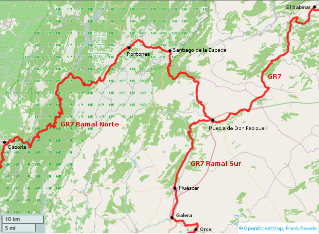
Cañada de la Cruz is village on GR7 20km north of Puebla de Don Fadrique, with fuente across from church, or ask residents for water if fuente turned off in cold weather. Fuente de los Almeces is on GR7 about 19km north of Cañada de la Cruz (14km south of El Sabinar) and runs reliably in spring and early summer.
Cazorla (see below)
Huéscar
- Hotel** El Maño Andalucía, 958 740 422. 70€ single, 80€ double occupancy, according to website Jan 2014.
- Hotel* Patri, 958 742 504. South of town, on highway. €45 single €65 double, according to website Mar 2025. Paid €45 for single occupancy in Mar 2025.
- Hostal* Ruta del Sur, hostalrutadelsur, 666 801 264, 958 741 289. South of town, on highway. Paid 35€ for single occupancy in Mar 2024.
- Casa Rural El Molino de Portillo, 958 344 504, 685 205 997. About 5km north of town, on GR7. Rooms for rent.
- La Casa del Parque, 958 430 484, 654 850 802. 80€ for house for 2 persons, discount to 60€ Sun-Thu low season.
- Cuevas Atalaya, 958 741 607, 666 396 193. 80€ for house for 2 persons, 20% discount Sun-Thu low season.
- El Molino de Fuencaliente, 958 065 030, 636 958 280. 80€ for house for 4 persons.
Galera
- Hotel Galera, 958 739 555, 629 268 375. 35€ single, 49€ double occupancy, according to website Jan 2014.
- Casas Rural Cueva La Morada, 660 862 044, 690 671 937.
- Casas Rural El Mirador, 958 739 559, 639 600 264. 30€ single, 49€ double occupancy, according to website Jan 2014, and possible 20% discount for Sun-Thu.
- Apartamento El Molino de Morillas, 958 739 068. 1 km south of Galera, where GR7 joins highway.
Orce
- Two stores and bakery.
- Hotel/Restaurante La Morata, 660 550 816. Paid 25€ for single occupancy of luxurious room in renovated seignorial house in center of town, in Mar 2014. No answer when I called in Mar 2016. Could have checked with restaurant in Mar 2016, which was open, but decided I wanted to camp.
- Pensión El Albergue y Catering Villa de Orce, 958 746 109, 625 341 725. I called in Mar 2014, but apparently this place is only for groups, at least in the off-season.
Pontones
- Hotel* Ruta del Segura, 953 438 287.
Puebla de Don Fadrique
- Several supermarkets and bakeries. Limited selection of food and fresh bread available Sundays and holidays at Repsol gasoline station on highway.
- Hotel*** Los Collados de la Sagra, 958 344 471. Carretera de la Sagra.
- Hostal** Puerta de Andalucía, 958 721 340, 667 433 699. On the highway, direction Almaciles. Paid 30€ for single occupancy in Mar 2025.
- Turismo Rural Don Fadrique, 958 721 116.
- Casa Rural Cortijo de Abajo, 666 239 916.
- Encanto Andaluz, 609 189 356.
Sabinar, El (see above)
Santiago de la Espada
- Hotel** San Francisco, 953 438 072.
- Aparthotel Don Ramon, 667 631 050.
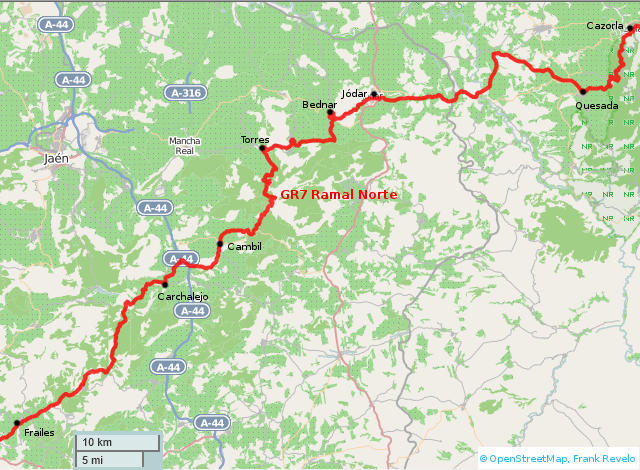
Cambil / Carchalejo (on the A-44 at the exit for Cambil)
- Hotel** Restaurante El Oasis, 953 302 083. 30€ single, 52€ double occupancy, according to website Feb 2014
Cazorla
- Hotel*** Ciudad de Cazorla, 953 721 700. 33€ single, 44€ double occupancy, weekdays in March, according to website Feb 2014.
- Hotel*** Parador de Cazorla, 953 727 075, 902 547 979. 65€ double occupancy, weekdays in March and early April, according to website Feb 2014.
- Hotel*** La Posada del Cordobés, 953 730 302, 650 427 812.
- Hotel*** Peña de los Halcones, 953 720 211, 953 721 335.
- Hotel*** Ruta del Sauce, 953 105 229, 953 065 028.
- Hotel*** Tharsis, 953 721 313. 45€ single, 55€ double occupancy, according to website Feb 2014.
- Hotel** Don Carlos, 953 710 134, 953 724 050. 40€ single, 55€ double occupancy, according to website Feb 2014 (5€ less on weekdays).
- Hotel** Guadalquivir, 953 720 268, 953 721 248. 40€ single, 53€ double occupancy, according to website Feb 2014.
- Hotel** Limas, 953 720 909. 25€ single, 45€ double occupancy, according to website Feb 2014.
- Hotel** Parque, 953 721 806, 615 067 755. 29€/32€ single, 39€/42€ double occupancy, according to website Feb 2014.
- Hotel** Puerta de Cazorla, 953 724 342.
- Hotel* Andalucía, 953 721 268, 666 533 313.
- Pensión Betis, 953 720 540.
- Pensión Taxi, 953 720 525, 606 587 657. 36€ double occupancy, according to website Feb 2014.
Quesada
- Hotel** Sierra de Quesada, 953 733 277, 615 623 909.
Jódar
- Hotel* Los Molinos, 953 787 732, 658 091 813. High season is Nov-Mar, according to website.
- Hotel** Ciudad Jódar, 953 785 051. 37€ single, 55€ double occupancy, according to website Feb 2014.
Frailes
- Pensión La Posa, 953 593 218.
- Pensión Ardales, 953 593 508, 600 388 589.
- Casa Rural El Mirador de Frailes, 607 621 711, 678 784 421.
Torres
- Casa Rural Imagina,
- Hotel*** Puerto Mágina, 953 363 192.
- Hotel** Jurinea, 953 363 021, 687 576 316.
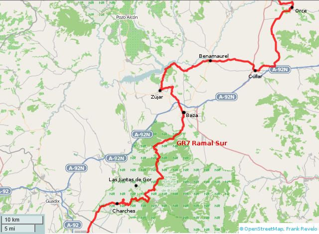
From La Calahorra to Baza about 67km. Buy 2.5 days food in La Calahorra, load up with 4L at Fuente La Fraguara (6km past Charches), camp 11km past Charches (32km day). Day 2, load up with 2L at Fuente de la Canaleja (28km past Charches), camp about 35km past Charches (24 km day). Day 3, descend to Baza (11 km day). If no vacancies at hotels in La Calahorra, then backtrqck and camp in forest nearby. Fuentes reliable in March and probably April and May, not sure about other months.
Baza
- Hotel** Abadí, 958 700 073. A92 autovía (5km northeast of Plaza Mayor, where Carretera Murcia merges with autovía).
- Hotel** Anabel, 958 860 998, 657 862 876. c/María de Luna, 3 (at c/Enrique Enríquez). 33€ single, 45€ double, according to website Mar 2016.
- Hotel** Robemar, 958 861 290. Carretera Murcia (outside of town, 3km northeast of Plaza Mayor, next to hospital).
- Hostal* Venta del Sol, 958 700 300. Carretera de Murcia, 13 (at Avenida del Mediteráneo). 29€ single, 44€ double occupancy, according to website Jan 2014.
- Hostal* Casa Grande, 958 703 868, 610 927 023. Carretera de Ronda, 28 (at c/Panamá, south edge of town). Paid 35€ for single occupancy in Mar 2025.
- Hostal* Ronda, 958 861 023, 695 523 673. Carretera de Ronda, 6 (at c/Panamá, south edge of town).
- Hostal* Los Hermanos 958 701 880. Carretera Murcia (outskirts of town, northeast side, near Lidl, Mercadona, Dia, Consum).
- Hostal* San Carlos, 958 700 267, 651 699 527. Carretera Granada, 2 (at Carretera de Benamaurel). Advertising 34€ doubles on sign outside as of Mar 2016.
- Hostal* Avenida aka Restaurante Cascamorras, 958 700 377. Avenida José Mora (at c/Pintor Velázquez).
Cúllar
- Casa Cueva Pura, 958 190 693, 655 227 354. 25€ single, 40€ double occupancy, according to website Jan 2014. About 5km east of town, on the other side of the autoroute, in the hamlet of Pulpite. Follow the road from Cúllar to Pulpite, turn right before getting to the church.
- Hotel* Luna Mar, 958 732 607, 635 177 509, 615 710 638. On highway, south side of town. No vacancies when I called on Thursday in March 2023.
- Hostal* Montecarlo, 958 730 826, 661 327 876. On the GR7 and on the highway, at the west end of Cúllar. Paid 30€ for single occupancy in Mar 2025.
- Hostal Venta del Peral, 958 730 288, 659 256 238. 35€ single, 55€ double occupancy, according to website Jan 2014.
- Pensión Venta Quemada, 958 738 000.
Juntas de Gor, Las
- Albergue Rural Gorillo. 958 682 113, 667 747 813. About 4km from the GR7, along a dirt road, following the sign for village of Las Juntas. Apartments with bath, according to website.
Orce (see above)
Zújar
- Hotel*** La Alcanacia, 902 070 725, 958 191 000. 44€ single, 55€ double on a Tuesday in March, according to website Jan 2014.
- Hostal* Jaufil, 958 716 191. 25€ single, 35€ double occupancy, according to website Jan 2014.
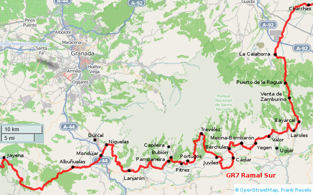
To get from Tímar to Lobras (towns located between Juviles and Cádiar), descend steeply from Tímar to the sendero local Acequias los Castaños, thereafter level path to Lobras. GR7 between these towns is deeply eroded, difficult to follow and of little scenic/cultural value compared to the Acequias trail. My GPX track shows both options.
Fuente just south of Puerto de la Ragua used to be reliable in March and probably also April and May. but was completely dry in both March 2022 and March 2023. Henceforth, carry 3L out of Bayárcal, which should be enough to get to Ferreira next day, unless extremely hot, in which case carry 4L.
GR7 between Bayárcal and Puerto de la Ragua has been increasingly overgrown every year I hiked it. Starting 2022, I gave up following the trail and stayed on the paved highway. North of Puerto de la Ragua, after leaving the paved highway, trail is okay until descent into Arroyo Chico, which was thorn infested in March 2023, though I managed (barely) to get through without any damage to clothing or skin. In future, might be better to stay on ridge between Arroyo Chico and Arroyo Hondo. Based on Google maps satellite view, ridge and east side of Arroyo Hondo are open. So cross to east side of Arroyo Hondo before reaching bottom of ridge, continue north 100m or so, then descend to road, and thus avoid thorn infested bottom of Arroyo Chico.
Albuñuelas
- Casa Rural El Cortijo del Pino, 958 776 257, 607 523 767. 65€ single, 85€ double occupancy, according to website Feb 2014.
Bérchules
- Hotel** Bérchules, 958 852 530, 958 769 000. 40€ single, 55€ double occupancy, according to website Feb 2014.
- Apartamentos El Cercado, 958 064 023. 65€ double occupancy, according to website Feb 2014.
- Casa Rural El Mirador de Bérchules, 958 769 090, 646 552 153, 628 569 338, 690 312 505.
- Casa Rural El Paraje, 958 064 029, 626 186 035. 40€ single, 65€ double occupancy, according to website Feb 2014.
- Apartamentos El Vergel de Bérchules, 958 852 608, 659 756 885. 55€ for double occupancy of studio, according to website Feb 2014.
Bubión
- Hostal** Las Terrazas de La Alpujarra, 958 763 034, 675 557 281, 29€ single, 40€ double occupancy, according to website Mar 2020. Paid €29 for single occupancy in Mar 2020.
- HA Villa Turística, 958 763 973. Barrio alto, s/n.
- Casa Rural Los Tinaos, 958 763 192, 660 515 333.
- Casa Rural El Rincón del Ángel, 958 763 115, 626 466 181.
- Apartments Casalpujarra, 958 763 082, 609 487 309.
- Casa Rural Habitaciones La Sevillana 958 763 153, 628 132 357.
Busquístar (2km east of Pórtugos on GR7)
- Casa Rural Habitaciones Sonia, 958 857 593, 652 188 911.
Cádiar
- Hotel** Alquería de Morayma, 958 343 221. 2km south of city. 66€ double occupancy, according to website Feb 2014.
- Pensión El Montoro, 646 507 321. Paid €30 for single occupancy in Mar 2025.
- Apartamentos Ruta de la Alpujarra, 958 768 059. Located at edge of town, on highway to Berchules.
- Bar/Pensión El Cadí, 958 850 961. c/Real 21 (center of town, near church). Paid 25€ for single occupancy in Mar 2023.
La Calahorra
- Store across from Hostal Labella, panaderia on northeast side of town, on highway.
- Apartamentos Cuevas del Zenete, 958 698 296, 615 299 693. 62€ double occupancy according to website Feb 2014.
- Hotel**** Hospedería del Zenete, 958 677 192. Northeast of town, on outskirts. 57€ single, 71€ double occupancy weekday in Feb, according to website Feb 2014.
- Hostal Labella, 958 677 251, 640 090 395. On GR7, south side of town. 37€ single, 50€ double occupancy, on weekdays, according to website Mar 2025. Paid 37€ single occupancy Mar 2025.
- Hostal Manjón, 651 506 543. c/Las Cañes (near church). Paid 25€ single occupancy Mar 2014.
- Hostal El Castillo, 958 677 192. No vacancies when I called in Mar 2014.
- "Dutch B&B", sign advertising this place on GR7 outside of town, 622 798 351.
Capileira (2km north of Bubíon)
- Hotel*** Finca los Llanos, 958 763 071. Carretera Sierra Nevada s/n. 55€ single, 70€ double occupancy, according to website Jun 2014.
- Hostal** Poqueira (also Hotel** Poqueira II, Hotel Real de Poquira, Apartamentos Poqueira), 958 763 048, 958 763 902. c/Doctor Castilla, 5-6. Paid €35 for single occupancy at Hostal in Mar 2024.
- Hotel* El Cascapeñenas de la Alpujarra, 958 763 011. Carril s/n. 25€ single, 50€ double occupancy, according to website Jun 2014.
- Hostal* Atalaya, 958 763 025. c/Perchel, 4. Paid 35€ for single occupancy in March 2025.
- Hostal* Moraima, 958 763 180. Carretera de la Sierra s/n. 35€ double occupancy, according to website Jun 2014.
- Pensión Ruta de las Nieves, 958 763 106. Carretera de la Sierra s/n.
Dúrcal (several km north of GR7, buses leaves from Palacio de Congresos in Granada every half-hour weekdays, Palacio de Congresos is south of río Genil, Madrid-Granada bus drops off about 4km north of river)
- Pensión La Fonda, 958 780 730, 687 465 617. c/San José, 34 (north end of town, on main street). 22€/33€ single/double occupancy, according to booking.com Nov 2014.
- Pensión El Zahor, 958 780 101. Ctra Bailen Motril (about 1km north of town). 20€ single, 40€ double occupancy, according to website Jan 2014.
- Hostal** La Mezquita, 958 780 919. Ctra. Bailen Motril (about 2km north of town). 32€ for 1 room bungalow, according to booking.com Nov 2014.
- Hotel** Mariami, 958 003 141. c/Comandante Lazaro, 82 (center of town, on main street). Closed as of April 2013 according to their Facebook page.
Jayena (see below)
Juviles
- Pensión Tino, 958 769 174. Altillo Bajo, 38.
Lanjarón
- Most hotels in Lanjarón along the main road (Avenida Alpujarra). Lanjarón Tourism Office, 958 555 555.
- Hotel** Manolete, 958 770 773. c/San Sebastián, 3. Paid 30€ for single occupancy in Mar 2023.
- Pensión Astoria, 958 770 075, 606 933 212. Avenida Alpujarra, 5. 18€ single, 30€ double occupancy, according to website Jan 2014. No answer when I called in Mar 2014.
- Hotel** Central, 958 770 108. Avenida Alpujarra, 21. 25€ single, 35€ double occupancy, according to website Jan 2014. No answer when I called in Mar 2014.
- Hotel** Andalucía, 958 770 136. Avenida Alpujarra, 15. 32€ single, 41€ double occupancy, according to website Jan 2014. Paid 35€ for single occupancy in Feb 2016, including full breakfast (eggs, toast, yogurt, juice, coffee/tea).
- Hotel*** Castillo, 958 770 712. c/Granada, s/n. 40€ single, 50€ double occupancy, according to website Jan 2014.
- Hotel*** Alcadima, 958 770 809. c/General Rodrigo, 3. 50€ single, 60€ double occupancy, according to website Jan 2014.
- Hotel* Paris, 958 770 056, 617 590 833. Avenida Alpujarra, 23.
- Hotel** El Sol, 958 770 130. Avenida Alpujarra, 22.
- Hotel** Paraiso, 958 770 012. Avenida Alpujarra, 18. No answer when I called in Mar 2014.
- Hotel* España, 958 771 386. Avenida Alpujarra, 42.
- Hotel* Lanjarón, 958 770 094. c/Pérez Chaves, 7. Paid 60€ for 2 nights single occupancy in Mar 2025.
- Hotel**** Balneario, 958 770 137. Avenida Madrid, 2.
- Hotel*** Miramar, 958 770 161. Avenida Alpujarra, 10.
- Hotel*** Nuevo Palas, 958 770 086. Avenida Alpujarra, 28.
Laroles
- Hotel** Real de Laroles, 958 760 058. 50€ double occupancy, according to website Feb 2014.
- Hostal Refugio de Nevada, 958 760 320. Carretera del puerto, s/n. 44€/day according to www.granada-turismo.com.
- Casa Rural Fuentezuelas, 626 422 076. 60€ double occupancy, according to website Feb 2014.
- Casa Rural Barranco de la Salud, 958 760 358, 679 428 745. 50€ double occupancy if only staying 1 night, lower rates for 2 nights or more, according to website Feb 2014.
- Camping Alpujarras, 659 843 382, 607 456 721. 9€/parcel + 4.5€/adult, 17€/adult in albergue.
Lobras (between Juviles and Cádiar)
- Apartamentos El Huerto de Lobras, 958 768 112, 651 155 264.
Mecina Bombarón
- Altas Vistas, 958 851 370, 616 884 892.
- Casas Rurales Benarum, 958 851 149, 676 612 225. 75€ double occupancy of complete apartment, according to website Feb 2014.
- Casa La Bombarón, 958 851 113, 676 737 747. 30€ single, 50€ double occupancy, according to website Feb 2014.
- Casas Blancas, 958 851 151, 626 440 491.
- Apartamento Los Macabes, 958 064 022, 696 472 678.
- Mirador del Avellano, 958 131 498.
Mondújar
- Casa Rural Casita de la Vaca, 958 788 979, 667 696 465. 30€ single, 40€ double occupancy, according to website Feb 2014.
Niguelas
- Hotel Alquería de los Lentos, 958 777 850, 690 754 689. 75€ double occupancy, according to website Feb 2014.
- Casa Rural La Huerta del Cura,
Pampaneira
- Hotel*** Estrella de las Nieves, 958 763 981, 671 420 833. c/Huerto, 21. 70€ double occupancy, according to website Feb 2014.
- Hostal** Pampaneira, 958 763 002, 645 555 225. Avenida Alpujarras, 1 (main highway). 31€ single, 42€ double occupancy, according to website Feb 2014.
- Hostal Barranco del Poqueira, 958 763 004, 655 995 855. Plaza de la Libertad, 8 (address of bar Martín, which manages pensión). Paid 25€ for single occupancy in Mar 2014, 42€ in Feb 2016.
- Casa Rural Habitaciones El Tinao de Chicho, 958 763 170, 655 995 856.
Pitres
- Hotel** Posada San Roque, 958 857 528. Paseo Maritimo, 57-59. 40€ single occupancy, 58€ double occupancy, according to booking.com Jun 2014.
- Hotel rural** Maravedi, 958 776 292, 616 676 342, 630 316 721. 55€ double occupancy, according to website Jun 2014.
- Camping Balcón de Pitres, 958 766 111, 958 766 112. Camping 5€/tent + 5€/adult, cabins 40€ double occupancy, according to website Feb 2014.
Pórtugos
- Hotel** Nuevo Malagueño, 958 766 098. Carretera Orgiva-Trevelez s/n. Paid 45€ for single occupancy in Feb 2016.
- Pensión Mirador de Pórtugos, 958 766 014. Plaza Nueva, 5. Closed for repairs Feb 2016.
- Casa Rural La Placeta, 958 103 792, 696 859 615.
- Alojamientio Rural Maria Jesús, 678 511 037.
Soportújar (between Lanjarón and Pampaneira)
- Apartamentos La Huerta, 669 034 657, 625 811 929. 50€ double occupancy, according to website Feb 2014.
Trevélez
- Hostal Casa Fermina, 958 858 542, 676 428 531, 606 519 708. Haza del Castaño Nº 9 (just off highway, lower town). Paid 30€ for single side occupancy in March 2025.
- Hotel La Fragua I, 958 858 626, 958 858 512. c/Posadas s/n (upper town). 50-55€ double occupancy according to website Mar 2025.
- Hotel* Pepe Álvarez, 958 858 503, 679 657 623. Plaza Francisco Abellán s/n (lower town). 56€ double occupancy, according to website Mar 2025.
- Hostal Mulhacén, 958 858 587, 653 960 153. Carretera Ugíjar s/n. (lower town). Paid €33 through booking.com for single occupancy in Mar 2024.
- Hostal** Regina, 958 858 564. Plaza Francisco Abellán s/n (lower town).
- Hostal* Fernando, 958 858 565. Pista s/n (upper town). Paid 25€ for single occupancy in Mar 2020. Located towards the upper part of town, on the main road. Appears closed as of March 2022.
- Apartamentos Siete Lagunas, 958 858 726.
- Camping Trevélez, 958 858 735. 9€ solo hiker with tent. They also have some inexpensive cabins for rent.
Ugíjar (5km south of Válor)
- Pensión Vidaña, 958 767 010. Carretera Almería s/n.
- Pensión Pedro, 958 767 149. Fábrica de Sedas s/n.
Válor
- Pensión** Las Perdices, 958 851 821. Carretera s/n (center of town). Paid 30€ for single occupancy of nice double room with bath on Thursday in Mar 2014, would be 40€ for double occupancy. Said they were closed for the day when I called on Wednesday in Mar 2016.
- Pensión Los Arcos, 958 851 771. Plaza de la Iglesia s/n. 40€ single, 60€ double occupancy, according to website Feb 2014.
- Apartamentos Balcón de Válor, 958 851 821. East end, top of town, on GR7.
Venta el Zamburino
- Hostal** Posada de los Arrieros, 958 190 692. On GR7. Closed in March of every year from 2016 to 2020, appears abandoned. Reliable fuente inside gates.
Yegen
- Alojamiento Almeriya, c/La Cruz 13, 630 702 183, 686 644 857.
- Pensión La Fuente, c/Nacimiento 2, 958 851 067, 639 306 258. Paid €40 single occupancy through booking.com in Mar 2024.
- Alojamiento Las Eras, Carretera 39, 958 851 191, 636 879 310.
- La Huerta, Calle Real 44, 625 811 929.
- Alojamiento El Rincón de Yegen, Carretera s/n, 958 851 270.
- Pensión El Tinao, Carretera s/n, 958 851 212, 616 644 677. English-speaking owner. Paid 45€ for single occupancy in Mar 2025.
- Hostal Casa de La Ladera, located between Yegen and Válor on the highway and on the GR7.
Alcalá la Real
- Hotel*** Torrepalma, 953 581 800.
- Hotel* Hospedería Zacatín, 953 580 568. 28€ single, 45€ double occupancy, according to website Feb 2014.
- Hostal Río de Oro, 953 580 337, 680 578 284. 23€ single, 40€ double occupancy, according to website Feb 2014.
- Hostal Sierra Martina, 953 121 388, 953 121 355.
- Apartamentos Spa Llave de Granada, 953 583 691, 651 374 143. 70€ double occupancy (54€ weekdays), according to website Feb 2014.
Alhama de Granada
- See also Alhama de Granada Tourist Office
- Pensión* San José, 958 350 156. Plaza Constitución, 25 (main plaza). 20€ single occupancy, 35€ double occupancy according to website May 2014. Paid 20€ for single occupancy of double room in Mar 2014.
- Hostal** Ana, 958 360 108, 690 884 045, 676 087 080. Ctra. de Granada, 10 (near Plaza Duque de Mandras). 30€ single, 50€ double occupancy, according to website Jan 2014.
- Hostal Rural El Ventorro, 958 350 438. Ctra. de Játar, Km. 2, near the Rio Alhama dam. 40€ single / 60€ double occupancy, 70€ double occupancy for underground cave rooms, according to website Jan 2014.
- Casa Rural La Sequiriya, 958 360 636. C/ Peñas, 12. 60€ double occupancy, according to website Jan 2014.
- Hotel Balneario Alhama de Granada, 958 350 011.
- Hotel** Los Caños de la Alcaicería, 958 350 325. Ctra. Vélez Málaga, km. 10.
Antequera
- Hospedería Colon, 902 902 749. 25€ single, 35€ double occupancy, according to website Jan 2014. Paid 20€ in Feb 2014 for single occupancy. Located in middle of town.
- Pensión El Toril.
- Hostal Reyes.
- Hostal El Número Uno.
- Casa del Conde de Pinofiel.
- Nuevo Infante.
- Hostal Manzanito.
- Pensión Madrona.
- Hotel Coso Viejo.
- Pensión Pepe.
- Parador de Antequera.
- Hotel Castilla.
- Hotel La Fuente del Sol.
- Pensión Toril.
- Hotel Plaza San Sebastian.
Arenas del Rey
- Camping Los Bermejales, 958 359 190.
Cuevas de San Marcos
- Hotel*** Casa Bob, 952 728 231, 690 217 055. 20€ single, 30€ double occupancy, according to website Feb 2014.
- Hotel***-Apartamento Spa Coto Mi Refugio, 951 904 906, 951 904 300, 610 757 533.
- Hostal Vista Bella, 952 728 123.
Frailes (see above)
Jayena
- Pensión** Hospedería La Almijara, 958 364 157. Paid 23€ for single occupancy in Mar 2014.
Priego de Córdoba
- Hotel**** Huerta de las Palomas, 957 720 305, 957 720 393. Located 3km northwest of town, on co-8211. 69€ double occupancy weekday in March, according to website Feb 2014.
- Hotel** Hospedería San Francisco, 957 701 917. 45€ single, 52€ double occupancy weekday in March, according to website Feb 2014.
- Hotel** Las Rosas, 957 540 449. 30€ single, 49€ double occupancy in March, according to website Feb 2014.
- Hotel** Río Piscina, 957 700 186, 957 701 068.
- Hotel*** Villa de Priego de Córdoba, 957 703 503. 39€ double occupancy in March, according to website Feb 2014.
- Hostal** Zahorí, 957 547 292. 36€ single, 55€ double occupancy, according to website Feb 2014.
Riogordo
- Hostal La Era, 952 732 320, 607 684 385. 32€ single / 42€ double occupancy, according to website Jan 2014.
Rute
- Hotel*** El Mirador de Rute, 957 539 404, 957 532 899.
- Hotel*** Cortijo La Prensa, 957 724 299, 606 313 532.
- Hotel*** María Luisa, 957 538 096. 61€ double occupancy (via calculation from a special offer), according to website Feb 2014
Valle de Abdalajís (see below)
Ventas de Zafarraya
- Pensión Aquí te quiero ver, 958 362 001. South end of town, on the highway.
Villanueva de Cauche
- Hotel** Las Pedrizas, 952 730 751, 607 537 900. On the highway. Paid 20€ for single occupancy in Feb 2014.
Villanueva de Algarides
- Hotel** La Rincona, 952 745 008.
- Hostal Algaidas, 952 743 308.
Villanueva del Rosario
- Hostal El Cerezo, 952 742 129.
- Hotel* Venta Las Delicias, 952 742 094. 16-33€ according to hotelsearch.com.
- Hotel*** El Rosario, 952 742 154.
Villanueva del Trabuco
- Hotel* Paneque Ruiz, 951 904 716, 654 563 910.
Villanueva de Tapia
- Hotel* La Paloma, 952 750 409, 692 602 617. 59€ double occupancy, according to website Feb 2014.
Ardales
- Hotel*** Boutique Posada del Conde, 952 112 411, 952 112 800.
- Hostal Restaurante El Cruce, 952 459 012.
- Pensión Bobastro, 952 458 081.
Chorro, El
- Pensión Estación El Chorro, 952 495 004.
- Camping Estación El Chorro, 952 495 244. 8€ solo adult with tent, 12€ albergue (8 beds/cabin), 45€ 2 person cabin.
- La Garganta, 952 495 000. 77€ double occupancy, according to website Jan 2014.
Cuevas del Becerro (5km west of Serrato)
- Casa Alfredo, 952 163 008.
Ronda
- Hotel Andalucía, 952 875 450. 22€ single, 30€ double occupancy in March, according to website Feb 2014.
- Hotel* Berlanga, 952 875 626, 952 873 336. 25€ single, 40€ double occupancy, according to website Feb 2014.
- Hotel* Arunda I y II, 952 190 102. 22€ single, 30€ double occupancy, according to website Feb 2014.
- Hotel** Royal, 952 871 141, 952 871 142. 28€ single, 30€ double occupancy in March, according to website Feb 2014.
- Hostal Virgen del Rocío, 952 877 425. 35€ double occupancy, according to website Feb 2014.
- Hotel** San Cayetano, 952 161 212, 952 879 273. 34€ single, 40€ double occupancy in March, according to website Feb 2014.
- Hotel Polo, 952 872 447. 40€ double occupancy weekdays in March, according to website Feb 2014.
- Hostal Rondasol, 952 874 497.
- Pensión Boutique Baraka, 952 872 843, 610 390 945. 57€ single, 70€ double occupancy, according to website Feb 2014.
- Hotel** Aire de Ronda, 952 161 274, 647 285 077. 88€ double occupancy weekdays in March, according to website Feb 2014.
- Hotel** San Francisco, 952 873 299.
- Hotel** Virgen de los Reyes, 952 871 140, 689 515 085.
- Hotel** El Espejo, 952 114 011, 680 961 134.
- Pensión/Hostal Doña Carmen, 952 871 994.
- Many other options.
Ubrique
- Hotel** Ocurris, 956 463 939, 956 463 924. ?€ single / ?€ double occupancy, according to website June 2013.
- Hotel*** Sierra de Ubrique, 956 466 805, 956 466 806. 38€ single, 60€ double occupancy, according to website Feb 2014.
- Apartamentos Casa Emilia, 956 464 987, 657 993 890. 50€ double occupancy, according to website Feb 2014.
Valle de Abdalajís
- Hotel** El Refugio de Alamut, 952 489 064. 36€ single, 52€ double occupancy, according to website Feb 2014. About 1km north of town on highway. Paid 25€ for solo occupancy in Feb 2014.
- Hostal Avenida, 952 489 177, 952 489 380. On main road near center of town.
- Pensión Moya, 952 489 098, 952 488 185. Closed when I called in Feb 2014.
- Hostal Vista a la Sierra, 952 488 052. On main road at north end of town.
Barrios, Los
- Hotel* Real, 956 620 024. (On Avenida Antonio Machado, about 3km from GR7.)
- Hotel**** Montera, 856 220 220. 51€ single / 60€ double occupancy, according to website June 2013. (On Avenida Carlos Cano, about 4km from GR7.)
- Pensión Diemo, 956 621 571. (Near the Los Barrios train station, close to A7, about 8km from GR7.)
Castillo de Castellar
- Castillo de Castellar, 956 693 150. 66€ double occupancy of "casa rural", according to website Feb 2014.
Jimena de la Frontera
- Hostal** Casa Henrietta, 956 648 130. 50€ single, 65€ double occupancy, according to website Feb 2014.
- Hostal* El Anón, 956 640 113. 42€ single, 60€ double occupancy, according to website Feb 2014.
- Posada La Casa Grande, 956 641 120 / 675 648 863. 35€ single, 50€ double occupancy, according to website March 2017.
- Rancho Los Lobos, 956 640 429. 35€ single, 65€ double occupancy, according to website Feb 2014. (Located on the GR7, south of Jimena de la Frontera.)
- Hostal* Los Arcos, 956 640 328. (Located in Los Ángeles, just southeast of Jimena de la Frontera.)
- Camping Los Alcornales, 956 640 060. 10€ single adult with tent, 45€ small bungalow (up to 3 persons), according to website Feb 2014.
Tarifa
- Hostal* Las Margaritas, 956 680 030. 30€ single, 40€ double occupancy, according to website Feb 2014.
- Hostal* Medina, 956 684 904.
- Hostal* Apartamentos La Hormiga Voladora, 956 688 562. 55€-70€ double occupancy, according to website Feb 2014.
- Hostal* La Calzada, 956 681 492.
- Hostal* Alameda, 956 681 181. 70€ double occupancy for March, according to website Feb 2014.
- Hostal* Hospedería Almundo, 956 682 620, 622 652 779.
- Hostal* El Levante, 956 681 775. 48€ double occupancy, according to website Feb 2014. (Located 2km north of the town of Tarifa, on the N-340.)
- Hostal** Alborada, 956 681 140. 40€ single, 50€ double occupancy, according to website Feb 2014.
- Hostal* Tarik, 956 680 648. 69€ double occupancy, according to website Feb 2014.
- Hostal* Room Tarifa, 956 682 229, 605 093 828. 60€ double occupancy, according to website Feb 2014.
- Hostal* Medina II, 956 684 904.
- Pensión Facundo, 956 684 298, 956 684 536. 22€ for single occupancy with shared bath, according to website June 2013.
- Hostal La Estrella de Tarifa, 956 681 985, 670 739 723. 59€ double occupancy (Mar-May), according to website June 2013.
- Hostal El Asturiano, 956 680 619. 30€ single, 50€ double occupancy (Feb-Mar), according to website Feb 2014.
- Hostal Dori, 956 685 317. 45€ double occupancy, according to website Feb 2014.
- Pensión Correo, 956 680 206, 650 208 903. 24€ double with shared bath (Feb-Mar 2014), according to website Feb 2014.
- Pensión Casablanco, 956 681 515.
- Pensión Hostería Tarifa, 956 684 076.
- Pensión Avenida, 956 684 818.
- Many other options.